
Fai una donazione
Preparati per la tua prossima avventura:
In qualità di associato Amazon, questo sito riceve una commissione sugli acquisti idonei senza alcun costo aggiuntivo per te.
Mappa topografica Crumpler
Clicca sulla mappa per visualizzare l'altitudine.
Fai una donazione
Preparati per la tua prossima avventura:
In qualità di associato Amazon, questo sito riceve una commissione sugli acquisti idonei senza alcun costo aggiuntivo per te.
A proposito di questa mappa
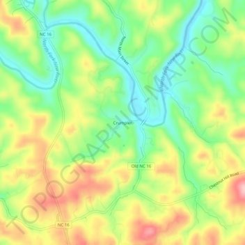
Nome: Mappa topografica Crumpler, altitudine, rilievo.
Luogo: Crumpler, Ashe County, North Carolina, 28617, United States (36.48401 -81.41427 36.52401 -81.37427)
Altitudine media: 838 m
Altitudine minima: 765 m
Altitudine massima: 931 m
Fai una donazione
Preparati per la tua prossima avventura:
In qualità di associato Amazon, questo sito riceve una commissione sugli acquisti idonei senza alcun costo aggiuntivo per te.
Altre mappe topografiche
Clicca su una mappa per visualizzarne la topografia, l'altitudine e il rilievo.
West Jefferson
United States > North Carolina > Ashe County
West Jefferson is a popular destination among tourists and retirees from Florida, as well as those from the lower elevations of the Carolinas and Georgia.
Altitudine media: 1.002 m
Jefferson
United States > North Carolina > Ashe County
Due to its high elevation, Jefferson has an oceanic or subtropical highland climate, (Köppen Cfb), with the coldst month of January averaging slightly above freezing, while summers are much milder than most of the southeast, with July averaging below 70 degrees fahrenheit.
Altitudine media: 979 m
Lansing
United States > North Carolina > Ashe County
Lansing is a popular destination among retirees and tourists from Florida, as well as those from the lower elevations of the Carolinas and Georgia.
Altitudine media: 879 m
Jefferson
United States > North Carolina > Ashe County
Due to its high elevation, Jefferson has an oceanic or subtropical highland climate, (Köppen Cfb), with the coldst month of January averaging slightly above freezing, while summers are much milder than most of the southeast, with July averaging below 70 degrees fahrenheit.
Altitudine media: 979 m
Fai una donazione
Preparati per la tua prossima avventura:
In qualità di associato Amazon, questo sito riceve una commissione sugli acquisti idonei senza alcun costo aggiuntivo per te.
West Jefferson
United States > North Carolina > Ashe County
West Jefferson is a popular destination among tourists and retirees from Florida, as well as those from the lower elevations of the Carolinas and Georgia.
Altitudine media: 1.002 m