
Mappa topografica Gulmarg
Clicca sulla mappa per visualizzare l'altitudine.
Gulmarg
Yousuf Shah Chak, who ruled Kashmir from 1579 to 1586, frequented the place with his queen Habba Khatoon and renamed it 'Gulmarg' ("meadow of flowers"). Wild flowers of 21 different varieties were collected by the Mughal emperor Jahangir for his gardens in Gulmarg. In the 19th century, British civil servants started using Gulmarg as a retreat to escape summers in the Indo-Gangetic plains. Hunting and golfing were their favorite pastime and three golf courses were established in Gulmarg including one exclusively for women. One of the golf courses is located at an altitude of 2,650 metres (8,690 ft) is the world's highest golf course. In 1927, British established a ski club in Gulmarg and two annual ski events were hosted, one during Christmas and Easter. Central Asian explorer Aurel Stein also visited Gulmarg during this period.
A proposito di questa mappa
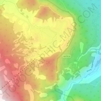
Nome: Mappa topografica Gulmarg, altitudine, rilievo.
Luogo: Gulmarg, Tangmarg, Baramulla, Jammu and Kashmir, 193403, India (34.02897 74.37212 34.06897 74.41212)
Altitudine media: 2.590 m
Altitudine minima: 2.165 m
Altitudine massima: 3.047 m
Altre mappe topografiche
Clicca su una mappa per visualizzarne la topografia, l'altitudine e il rilievo.