
Mappa topografica Pine
Clicca sulla mappa per visualizzare l'altitudine.
Pine
Pine and the adjacent community of Strawberry are rapidly growing vacation and retirement centers in north-central Arizona, below the Mogollon Rim. Pine's elevation is 5,448 feet (1,661 m), and the Pine post office was established in 1884.
A proposito di questa mappa
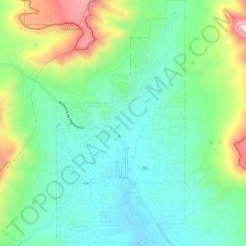
Nome: Mappa topografica Pine, altitudine, rilievo.
Luogo: Pine, Gila County, Arizona, 85544, United States (34.37097 -111.47143 34.41879 -111.44099)
Altitudine media: 1.794 m
Altitudine minima: 1.613 m
Altitudine massima: 2.221 m
Altre mappe topografiche
Clicca su una mappa per visualizzarne la topografia, l'altitudine e il rilievo.
Star Valley
United States > Arizona > Gila County > Star Valley
According to the United States Census Bureau, the town has a total area of 36.1 square miles (93.6 km2), of which 0.01 square miles (0.02 km2), or 0.03%, is water. Star Valley sits at an elevation of 4,650 feet (1,420 m) and takes its name from the valley in which it is located, formed by Houston Creek, which…
Altitudine media: 1.521 m