
Fai una donazione
Preparati per la tua prossima avventura:
In qualità di associato Amazon, questo sito riceve una commissione sugli acquisti idonei senza alcun costo aggiuntivo per te.
Mappa topografica Highland Park
Clicca sulla mappa per visualizzare l'altitudine.
Fai una donazione
Preparati per la tua prossima avventura:
In qualità di associato Amazon, questo sito riceve una commissione sugli acquisti idonei senza alcun costo aggiuntivo per te.
Highland Park
In 1867, ten men purchased Highland Park for $39,198.70. They were the original stockholders of the Highland Park Building Company. Following construction of the Chicago and Milwaukee Railroad, a depot was established at Highland Park and a plat, extending south to Central Avenue, was laid out in 1856. At that point, Highland Park was settled on mostly scattered farms and undeveloped forested land. Highland Park was established as a city on March 11, 1869, with a population of 500, and evolved from the two settlements of St. John and Port Clinton; St. John's Avenue and Port Clinton Square are named after the settlements. Highland Park was named from its parklike setting at a lofty elevation relative to the lake, and was given its name from Walter S. Gurnee. The town annexed the village of Ravinia in 1899.
Fai una donazione
Preparati per la tua prossima avventura:
In qualità di associato Amazon, questo sito riceve una commissione sugli acquisti idonei senza alcun costo aggiuntivo per te.
A proposito di questa mappa
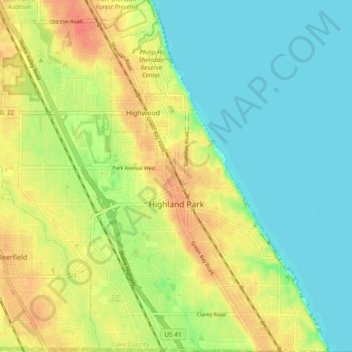
Nome: Mappa topografica Highland Park, altitudine, rilievo.
Luogo: Highland Park, Lake County, Illinois, United States (42.15226 -87.85206 42.22231 -87.75885)
Altitudine media: 194 m
Altitudine minima: 174 m
Altitudine massima: 220 m
Fai una donazione
Preparati per la tua prossima avventura:
In qualità di associato Amazon, questo sito riceve una commissione sugli acquisti idonei senza alcun costo aggiuntivo per te.
Altre mappe topografiche
Clicca su una mappa per visualizzarne la topografia, l'altitudine e il rilievo.
Illinois Beach State Park
United States > Illinois > Lake County
The park is located in the 12 mile long Zion Beach Ridge Plain. The Zion Beach Ridge Plain is 3,700 years old and composed of curvilinear ridge-and-swale topography. The beach ridges support black oak savanna habitat, while wetlands dominate the swales. The Zion Beach Ridge Plain has been migrating south…
Altitudine media: 178 m
Fai una donazione
Preparati per la tua prossima avventura:
In qualità di associato Amazon, questo sito riceve una commissione sugli acquisti idonei senza alcun costo aggiuntivo per te.
Fai una donazione
Preparati per la tua prossima avventura:
In qualità di associato Amazon, questo sito riceve una commissione sugli acquisti idonei senza alcun costo aggiuntivo per te.
Fai una donazione
Preparati per la tua prossima avventura:
In qualità di associato Amazon, questo sito riceve una commissione sugli acquisti idonei senza alcun costo aggiuntivo per te.
Lake Naomi
United States > Illinois > Lake County > Hawthorn Woods > White Birch Lakes
Altitudine media: 261 m
Bishops Ridge
United States > Illinois > Lake County > Kildeer > Bishops Ridge
Altitudine media: 253 m