
Fai una donazione
Preparati per la tua prossima avventura:
In qualità di associato Amazon, questo sito riceve una commissione sugli acquisti idonei senza alcun costo aggiuntivo per te.
Mappa topografica Mount Tahtali
Clicca sulla mappa per visualizzare l'altitudine.
Fai una donazione
Preparati per la tua prossima avventura:
In qualità di associato Amazon, questo sito riceve una commissione sugli acquisti idonei senza alcun costo aggiuntivo per te.
Mount Tahtali
Tahtalı Dağı lies on the east coast of the Teke Peninsula (Lycian Peninsula), dominating the landscape around Kemer. Located between Antalya and Finike and the dominant peak of the mountain range Bey Dağları (Turkish: Bey Mountains). From it, the start of the Taurus Mountains can be seen. Its close proximity to the coast of the Mediterranean Sea also make it visible from afar to mariners. It is the highest mountain in the Natural Park of Olympos - Beydağları - Milli Park. From November and often into June, the summit is covered with ice and snow. In spring dust in the Saharan winds color these peaks reddish brown. During summer they are often obscured by clouds. The tree line starts at about 1900 meters altitude.
Fai una donazione
Preparati per la tua prossima avventura:
In qualità di associato Amazon, questo sito riceve una commissione sugli acquisti idonei senza alcun costo aggiuntivo per te.
A proposito di questa mappa
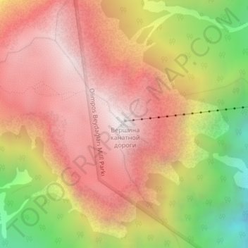
Nome: Mappa topografica Mount Tahtali, altitudine, rilievo.
Luogo: Mount Tahtali, Kemer, Antalya, Mediterranean Region, Turkey (36.53624 30.44213 36.53634 30.44223)
Altitudine media: 1.790 m
Altitudine minima: 926 m
Altitudine massima: 2.357 m
Fai una donazione
Preparati per la tua prossima avventura:
In qualità di associato Amazon, questo sito riceve una commissione sugli acquisti idonei senza alcun costo aggiuntivo per te.