
Mappa topografica Ivanjica
Mappa interattiva
Clicca sulla mappa per visualizzare l'altitudine.
A proposito di questa mappa
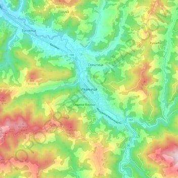
Nome: Mappa topografica Ivanjica, altitudine, rilievo.
Altitudine media: 670 m
Altitudine minima: 417 m
Altitudine massima: 1.098 m
Ivanjica lies in the southwest of Serbia, at the bank of the Moravica river. It is surrounded by the mountain ranges of Golija, Javor, Mučanj, Čemerno and Radočelo and is in a valley. Ivanjica's highest elevation is 1833 m, at the Jankov Kamen peak. The mountains in this area belong to the Dinaric range. The local environment includes forests and clearings, pastures, springs and rivers, wild fruit, 'medicinal' herbs and various game.