
Mappa topografica Caniçal
Mappa interattiva
Clicca sulla mappa per visualizzare l'altitudine.
Caniçal
Caniçal borders the municipal seat of Machico on its western frontier, and is surrounded by the Atlantic Ocean on the remaining borders. The roughly escarped terrain is prominent in the western border, where altitudes reach 800 metres above sea level and ravines are semi-active or dry year round. The urbanized and residential lands are located in a semi-gently sloping central area, while to the eastern coast, the land extends into a long narrow isthmus at Ponta de São Lourenço. Although most of the mountainous western region is forested, most of the remaining areas of the parish are populated with smaller species of herbaceous bushes, trees and pasturelands, until the Ponta de São Lourenço where vegetation is limited to sparse low-lying grasses.
A proposito di questa mappa
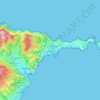
Nome: Mappa topografica Caniçal, altitudine, rilievo.
Luogo: Caniçal, Machico, Madeira, Portugal (32.72260 -16.76570 32.75762 -16.65525)
Altitudine media: 72 m
Altitudine minima: -1 m
Altitudine massima: 724 m
Altre mappe topografiche
Clicca su una mappa per visualizzarne la topografia, l'altitudine e il rilievo.