
Mappa topografica Vay
Clicca sulla mappa per visualizzare l'altitudine.
A proposito di questa mappa
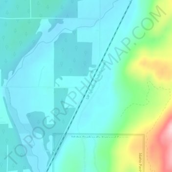
Nome: Mappa topografica Vay, altitudine, rilievo.
Luogo: Vay, Bonner County, Idaho, United States (48.10546 -116.78797 48.12546 -116.76797)
Altitudine media: 698 m
Altitudine minima: 649 m
Altitudine massima: 895 m
Altre mappe topografiche
Clicca su una mappa per visualizzarne la topografia, l'altitudine e il rilievo.
Hope
United States > Idaho > Bonner County
Hope is located at 48°14′55″N 116°18′33″W / 48.24861°N 116.30917°W / 48.24861; -116.30917 (48.248728, -116.309214), at an elevation of 2,192 feet (668 m) above sea level. The city sits on the northeast shore of Lake Pend Oreille.
Altitudine media: 763 m
Ponderay
United States > Idaho > Bonner County
Ponderay is located at 48°18′11″N 116°32′18″W / 48.30306°N 116.53833°W / 48.30306; -116.53833 (48.303080, -116.538292), at an elevation of 2,126 feet (648 m) above sea level. According to the United States Census Bureau, the city has a total area of 3.02 square miles (7.82 km2), of which,…
Altitudine media: 652 m
Priest River
United States > Idaho > Bonner County
Priest River is located at 48°11′0″N 116°54′34″W / 48.18333°N 116.90944°W / 48.18333; -116.90944 (48.183388, -116.909555), at an elevation of 2,139 feet (652 m) above sea level.
Altitudine media: 742 m
Priest River
United States > Idaho > Bonner County
Priest River is located at 48°11′0″N 116°54′34″W / 48.18333°N 116.90944°W / 48.18333; -116.90944 (48.183388, -116.909555), at an elevation of 2,139 feet (652 m) above sea level.
Altitudine media: 742 m
Clark Fork
United States > Idaho > Bonner County
Clark Fork is located at 48°8′50″N 116°10′42″W / 48.14722°N 116.17833°W / 48.14722; -116.17833 (48.147180, -116.178270), at an elevation of 2,090 feet (637 m) above sea level. The town is situated on the Clark Fork River, on the eastern shores of Lake Pend Oreille. in the northern…
Altitudine media: 681 m
Oldtown
United States > Idaho > Bonner County
Oldtown is located at 48°11′8″N 117°1′49″W / 48.18556°N 117.03028°W / 48.18556; -117.03028 (48.185623, -117.030158), at an elevation of 2,134 feet (650 meters).
Altitudine media: 682 m