
Fai una donazione
Preparati per la tua prossima avventura:
In qualità di associato Amazon, questo sito riceve una commissione sugli acquisti idonei senza alcun costo aggiuntivo per te.
Mappa topografica Grasmere
Clicca sulla mappa per visualizzare l'altitudine.
Fai una donazione
Preparati per la tua prossima avventura:
In qualità di associato Amazon, questo sito riceve una commissione sugli acquisti idonei senza alcun costo aggiuntivo per te.
Grasmere
The lake is 1680 yd (1540 m) long and 700 yd (640 m) wide, covering an area of 0.24 mi² (0.62 km²). It has a maximum depth of 70 ft (21m) and an elevation above sea level of 208 ft (62 m). The lake is both fed and drained by the River Rothay, which flows through the village before entering the lake, and then exits downstream into nearby Rydal Water, beyond which it continues into Windermere.
Fai una donazione
Preparati per la tua prossima avventura:
In qualità di associato Amazon, questo sito riceve una commissione sugli acquisti idonei senza alcun costo aggiuntivo per te.
A proposito di questa mappa
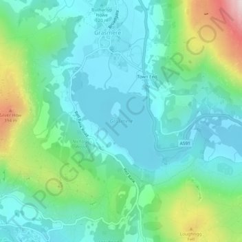
Nome: Mappa topografica Grasmere, altitudine, rilievo.
Altitudine media: 162 m
Altitudine minima: 54 m
Altitudine massima: 501 m
Fai una donazione
Preparati per la tua prossima avventura:
In qualità di associato Amazon, questo sito riceve una commissione sugli acquisti idonei senza alcun costo aggiuntivo per te.