
Fai una donazione
Preparati per la tua prossima avventura:
In qualità di associato Amazon, questo sito riceve una commissione sugli acquisti idonei senza alcun costo aggiuntivo per te.
Mappa topografica Spirit Lake
Clicca sulla mappa per visualizzare l'altitudine.
Fai una donazione
Preparati per la tua prossima avventura:
In qualità di associato Amazon, questo sito riceve una commissione sugli acquisti idonei senza alcun costo aggiuntivo per te.
Spirit Lake
Devils Lake State Park offers 29 miles of hiking trails that vary based on difficulty level, length, and terrain. Among the 17 established trails, the most popular is the tumbled rocks trail. It sits at the edge of the lake on the west end, stretching a mile long. The trail is paved, allowing it to be accessible for people with disabilities or visitors that wish to use a wheelchair, as well as ranked as "easy". Many visitors report to using this trail in order to find a spot to fish from or a rock jump off of. The parks most popular diving rock, Rock 8, can be accessed via the Tumbled Rocks trail. A second trail to highlight is the East Bluff Trail, with multiple overlooks and views, rock formations, and an abundance of wildlife. Rock formations pop up regularly throughout the trail, yet there are special appearances of the. "Elephant Rock" and "Elephant Cave" along the way, two famous landmarks of the park. The trail continues for 1.7 miles, gaining over 500 feet of elevation and is expected to take hikers anywhere between 1.5 to 3 hours to complete.
Fai una donazione
Preparati per la tua prossima avventura:
In qualità di associato Amazon, questo sito riceve una commissione sugli acquisti idonei senza alcun costo aggiuntivo per te.
A proposito di questa mappa
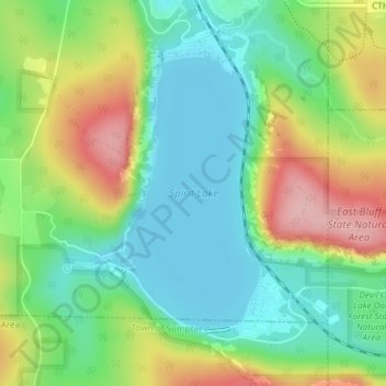
Nome: Mappa topografica Spirit Lake, altitudine, rilievo.
Altitudine media: 349 m
Altitudine minima: 291 m
Altitudine massima: 448 m
Fai una donazione
Preparati per la tua prossima avventura:
In qualità di associato Amazon, questo sito riceve una commissione sugli acquisti idonei senza alcun costo aggiuntivo per te.
Altre mappe topografiche
Clicca su una mappa per visualizzarne la topografia, l'altitudine e il rilievo.
Fai una donazione
Preparati per la tua prossima avventura:
In qualità di associato Amazon, questo sito riceve una commissione sugli acquisti idonei senza alcun costo aggiuntivo per te.