
Mappa topografica Mountain City
Mappa interattiva
Clicca sulla mappa per visualizzare l'altitudine.
A proposito di questa mappa
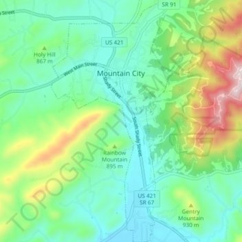
Nome: Mappa topografica Mountain City, altitudine, rilievo.
Altitudine media: 827 m
Altitudine minima: 691 m
Altitudine massima: 1.179 m
Mountain City is a town in and the county seat of Johnson County, Tennessee, United States. The population was 2,383 at the 2000 census and 2,531 at the 2010 census. It is the northeasternmost county seat in Tennessee. In addition, at an elevation of 2,418 feet (737 m), it has the distinction of being the highest incorporated city in the state.
Altre mappe topografiche
Clicca su una mappa per visualizzarne la topografia, l'altitudine e il rilievo.
Catface Mountain
United States > Tennessee > Johnson County
Catface Mountain, Johnson County, East Tennessee, Tennessee, 28615, United States
Altitudine media: 1.032 m
Cross Mountain
United States > Tennessee > Johnson County
Cross Mountain, Johnson County, Tennessee, United States
Altitudine media: 1.054 m
Shouns
United States > Tennessee > Johnson County > Mountain City
Shouns, Mountain City, Johnson County, Tennessee, 37638, United States
Altitudine media: 786 m
Sugar Creek
United States > Tennessee > Johnson County
Sugar Creek, Johnson County, Tennessee, 37680, United States
Altitudine media: 890 m
Butler
United States > Tennessee > Johnson County
Butler, Johnson County, East Tennessee, Tennessee, United States
Altitudine media: 671 m
Laurel Bloomery
United States > Tennessee > Johnson County
Laurel Bloomery, Johnson County, East Tennessee, Tennessee, 37680, United States
Altitudine media: 806 m
Trade
United States > Tennessee > Johnson County
Trade, Johnson County, East Tennessee, Tennessee, 27691, United States
Altitudine media: 1.035 m