
Fai una donazione
Preparati per la tua prossima avventura:
In qualità di associato Amazon, questo sito riceve una commissione sugli acquisti idonei senza alcun costo aggiuntivo per te.
Mappa topografica Pasil
Clicca sulla mappa per visualizzare l'altitudine.
Fai una donazione
Preparati per la tua prossima avventura:
In qualità di associato Amazon, questo sito riceve una commissione sugli acquisti idonei senza alcun costo aggiuntivo per te.
A proposito di questa mappa
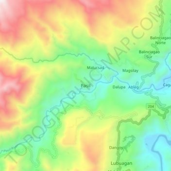
Nome: Mappa topografica Pasil, altitudine, rilievo.
Altitudine media: 933 m
Altitudine minima: 352 m
Altitudine massima: 1.845 m
Fai una donazione
Preparati per la tua prossima avventura:
In qualità di associato Amazon, questo sito riceve una commissione sugli acquisti idonei senza alcun costo aggiuntivo per te.
Altre mappe topografiche
Clicca su una mappa per visualizzarne la topografia, l'altitudine e il rilievo.
Chico River
The Chico River, has a total length of 233 kilometres (145 mi), making it the longest tributary of the Cagayan River, itself the largest river in the Philippines. For centuries it has been central to farming, trading, livelihoods, and daily life, whether as a benefit or hindrance. It provided a source of water…
Altitudine media: 585 m
Fai una donazione
Preparati per la tua prossima avventura:
In qualità di associato Amazon, questo sito riceve una commissione sugli acquisti idonei senza alcun costo aggiuntivo per te.
Chico River
The Chico River, has a total length of 233 kilometres (145 mi), making it the longest tributary of the Cagayan River, itself the largest river in the Philippines. For centuries it has been central to farming, trading, livelihoods, and daily life, whether as a benefit or hindrance. It provided a source of water…
Altitudine media: 585 m