
Mappa topografica Col de la Pierre Saint-Martin
Mappa interattiva
Clicca sulla mappa per visualizzare l'altitudine.
A proposito di questa mappa
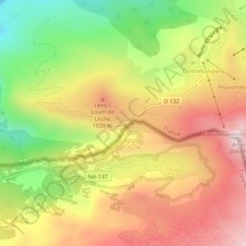
Nome: Mappa topografica Col de la Pierre Saint-Martin, altitudine, rilievo.
Altitudine media: 1.695 m
Altitudine minima: 1.349 m
Altitudine massima: 2.004 m
Col de la Pierre Saint-Martin (elevation 1,766 m (5,794 ft)) is a mountain pass on the France-Spain border in the western Pyrenees in the department of Pyrénées-Atlantiques (France) and Navarra (Spain). The climb from the Spanish side was used in the 2007 Tour de France.