
Mappa topografica Thompson Falls
Mappa interattiva
Clicca sulla mappa per visualizzare l'altitudine.
A proposito di questa mappa
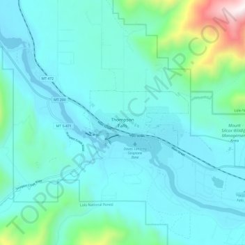
Nome: Mappa topografica Thompson Falls, altitudine, rilievo.
Altitudine media: 897 m
Altitudine minima: 709 m
Altitudine massima: 2.032 m
Thompson Falls is located at 47°35′48″N 115°20′37″W / 47.59667°N 115.34361°W / 47.59667; -115.34361 (47.596587, -115.343730) in the Clark Fork Valley at an elevation of 2,419 feet (737 m).