
Fai una donazione
Preparati per la tua prossima avventura:
In qualità di associato Amazon, questo sito riceve una commissione sugli acquisti idonei senza alcun costo aggiuntivo per te.
Mappa topografica Bushland
Clicca sulla mappa per visualizzare l'altitudine.
Fai una donazione
Preparati per la tua prossima avventura:
In qualità di associato Amazon, questo sito riceve una commissione sugli acquisti idonei senza alcun costo aggiuntivo per te.
Bushland
Bushland is located at 35°11′31″N 102°03′53″W / 35.19194°N 102.06472°W / 35.19194; -102.06472 (35.1919978, -102.0646392), at an elevation of 3,825 feet. The community is situated along Interstate 40, approximately 14 miles west of Amarillo in southwestern Potter County.
Fai una donazione
Preparati per la tua prossima avventura:
In qualità di associato Amazon, questo sito riceve una commissione sugli acquisti idonei senza alcun costo aggiuntivo per te.
A proposito di questa mappa
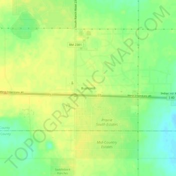
Nome: Mappa topografica Bushland, altitudine, rilievo.
Luogo: Bushland, Potter County, Texas, 79012, United States (35.17040 -102.08381 35.21040 -102.04381)
Altitudine media: 1.167 m
Altitudine minima: 1.154 m
Altitudine massima: 1.175 m
Fai una donazione
Preparati per la tua prossima avventura:
In qualità di associato Amazon, questo sito riceve una commissione sugli acquisti idonei senza alcun costo aggiuntivo per te.
Altre mappe topografiche
Clicca su una mappa per visualizzarne la topografia, l'altitudine e il rilievo.
Amarillo
United States > Texas > Potter County
Amarillo features a unique topography characterized by its high elevation and flat plains. The city averages around 3,600 feet (1,097 meters) above sea level, making it one of the highest major cities in Texas. The surrounding landscape consists of the Llano Estacado, a vast tabletop plateau that slopes…
Altitudine media: 1.098 m
Amarillo
United States > Texas > Potter County
Extreme temperatures range from −16 °F (−26.7 °C) on February 12, 1899 to 111 °F (43.9 °C) on June 26, 2011, but lows do not typically dip to 0 °F or −17.8 °C in most years, while highs above 100 °F or 37.8 °C are seen on 4.7 days on average. On average, there are 5.9 days of lows at or below 10…
Altitudine media: 1.097 m
Fai una donazione
Preparati per la tua prossima avventura:
In qualità di associato Amazon, questo sito riceve una commissione sugli acquisti idonei senza alcun costo aggiuntivo per te.