
Fai una donazione
Preparati per la tua prossima avventura:
In qualità di associato Amazon, questo sito riceve una commissione sugli acquisti idonei senza alcun costo aggiuntivo per te.
Mappa topografica Ishpeming
Clicca sulla mappa per visualizzare l'altitudine.
Fai una donazione
Preparati per la tua prossima avventura:
In qualità di associato Amazon, questo sito riceve una commissione sugli acquisti idonei senza alcun costo aggiuntivo per te.
Ishpeming
Ishpeming is in central Marquette County, 15 miles (24 km) west of Marquette, the county seat. It is bordered to the east by the city of Negaunee. According to the United States Census Bureau, Ishpeming has a total area of 9.35 square miles (24.22 km2), of which 8.74 square miles (22.64 km2) are land and 0.61 square miles (1.58 km2), or 6.50%, are water. Ishpeming's elevation is 1,436 feet (438 m) above mean sea level, which is over 800 feet (240 m) higher than that of nearby Lake Superior. The highlands of Ishpeming and the surrounding area, including the city of Negaunee to its east, receive an unusually high yearly average of lake-effect snow.
Fai una donazione
Preparati per la tua prossima avventura:
In qualità di associato Amazon, questo sito riceve una commissione sugli acquisti idonei senza alcun costo aggiuntivo per te.
A proposito di questa mappa
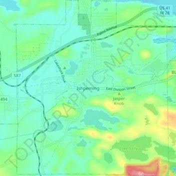
Nome: Mappa topografica Ishpeming, altitudine, rilievo.
Luogo: Ishpeming, Marquette County, Michigan, United States (46.46306 -87.69786 46.51389 -87.63378)
Altitudine media: 449 m
Altitudine minima: 411 m
Altitudine massima: 569 m
Fai una donazione
Preparati per la tua prossima avventura:
In qualità di associato Amazon, questo sito riceve una commissione sugli acquisti idonei senza alcun costo aggiuntivo per te.
Altre mappe topografiche
Clicca su una mappa per visualizzarne la topografia, l'altitudine e il rilievo.
Van Riper State Park
United States > Michigan > Marquette County > Michigamme Township
Altitudine media: 489 m
Fai una donazione
Preparati per la tua prossima avventura:
In qualità di associato Amazon, questo sito riceve una commissione sugli acquisti idonei senza alcun costo aggiuntivo per te.
Horseshoe Lake
United States > Michigan > Marquette County > Republic Township
Altitudine media: 503 m
Fai una donazione
Preparati per la tua prossima avventura:
In qualità di associato Amazon, questo sito riceve una commissione sugli acquisti idonei senza alcun costo aggiuntivo per te.