
Mappa topografica Tawang
Mappa interattiva
Clicca sulla mappa per visualizzare l'altitudine.
A proposito di questa mappa
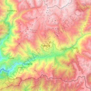
Nome: Mappa topografica Tawang, altitudine, rilievo.
Altitudine media: 3.280 m
Altitudine minima: 1.170 m
Altitudine massima: 4.913 m
Tawang is situated 448 km north-west of state capital Itanagar at an elevation of approximately 3,048 metres (10,000 ft). It lies to the north of the Tawang Chu river valley, roughly 10 miles (16 km) south of the Line of Actual Control with China. It is the site of a famous Gelugpa Buddhist monastery.
Altre mappe topografiche
Clicca su una mappa per visualizzarne la topografia, l'altitudine e il rilievo.
Bum La
India > Arunachal Pradesh > Tawang Circle
Bum La, Tawang Circle, Tawang District, Arunachal Pradesh, India
Altitudine media: 4.484 m