
Mappa topografica Hannington
Clicca sulla mappa per visualizzare l'altitudine.
A proposito di questa mappa
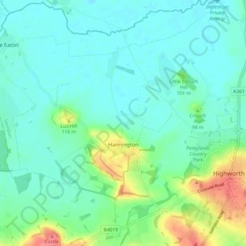
Nome: Mappa topografica Hannington, altitudine, rilievo.
Luogo: Hannington, Swindon, England, United Kingdom (51.61634 -1.77281 51.66984 -1.71879)
Altitudine media: 88 m
Altitudine minima: 71 m
Altitudine massima: 142 m
Altre mappe topografiche
Clicca su una mappa per visualizzarne la topografia, l'altitudine e il rilievo.
Swindon
United Kingdom > England > Swindon
Swindon has an oceanic climate (Cfb in the Köppen climate classification), like the vast majority of the British Isles, with cool winters and warm summers. The nearest official weather station is RAF Lyneham, about 10 miles (16 km) west southwest of Swindon town centre. The weather station's elevation is 145…
Altitudine media: 108 m