
Fai una donazione
Preparati per la tua prossima avventura:
In qualità di associato Amazon, questo sito riceve una commissione sugli acquisti idonei senza alcun costo aggiuntivo per te.
Mappa topografica Kamenz - Kamjenc
Clicca sulla mappa per visualizzare l'altitudine.
Fai una donazione
Preparati per la tua prossima avventura:
In qualità di associato Amazon, questo sito riceve una commissione sugli acquisti idonei senza alcun costo aggiuntivo per te.
Kamenz - Kamjenc
This small town is located in the west of the Upper Lusatia historic region (West Lusatia), about 40 km (25 mi) northeast of Dresden and about 30 km (19 mi) northwest of Bautzen. Situated on the Black Elster river, between the West Lusatian Hills and the Lusatian Highlands rising in the south, the town was built on greywacke and granite rocks which were mined here for centuries. Kamenz railway station is the terminus of Lübbenau–Kamenz and Kamenz–Pirna railway lines. It is served by Regionalbahn trains from Dresden Hauptbahnhof, operated by the Städtebahn Sachsen. The Hutberg hill west of the town centre, at an elevation of 293 m (961 ft), is the site of an extended landscape park laid out in 1893. It is known for its major rhododendron and azalea collections flowering at Pentecost. In 1864 the Lessing Tower was erected on the hilltop, offering a panoramic view over the West Lusatian lands and the Upper Lusatian Heath and Pond Landscape in the north. About 32% of the nature in former Kamenz District is under protection, including a network of routes for riding by bicycle and hiking.
Fai una donazione
Preparati per la tua prossima avventura:
In qualità di associato Amazon, questo sito riceve una commissione sugli acquisti idonei senza alcun costo aggiuntivo per te.
A proposito di questa mappa
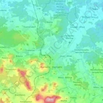
Nome: Mappa topografica Kamenz - Kamjenc, altitudine, rilievo.
Luogo: Kamenz - Kamjenc, Bautzen, Saxony, Germany (51.23001 13.99381 51.34336 14.17437)
Altitudine media: 186 m
Altitudine minima: 134 m
Altitudine massima: 382 m
Fai una donazione
Preparati per la tua prossima avventura:
In qualità di associato Amazon, questo sito riceve una commissione sugli acquisti idonei senza alcun costo aggiuntivo per te.
Altre mappe topografiche
Clicca su una mappa per visualizzarne la topografia, l'altitudine e il rilievo.
Koselbruch - Kózło
Germany > Saxony > Bautzen > Hoyerswerda - Wojerecy > Schwarzkollm - Čorny Chołmc
Altitudine media: 133 m