
Fai una donazione
Preparati per la tua prossima avventura:
In qualità di associato Amazon, questo sito riceve una commissione sugli acquisti idonei senza alcun costo aggiuntivo per te.
Mappa topografica Mount Brandon
Clicca sulla mappa per visualizzare l'altitudine.
Fai una donazione
Preparati per la tua prossima avventura:
In qualità di associato Amazon, questo sito riceve una commissione sugli acquisti idonei senza alcun costo aggiuntivo per te.
A proposito di questa mappa
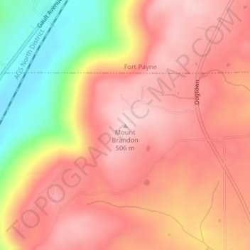
Nome: Mappa topografica Mount Brandon, altitudine, rilievo.
Luogo: Mount Brandon, DeKalb County, Alabama, United States (34.38504 -85.75335 34.38514 -85.75325)
Altitudine media: 419 m
Altitudine minima: 248 m
Altitudine massima: 509 m
Fai una donazione
Preparati per la tua prossima avventura:
In qualità di associato Amazon, questo sito riceve una commissione sugli acquisti idonei senza alcun costo aggiuntivo per te.
Altre mappe topografiche
Clicca su una mappa per visualizzarne la topografia, l'altitudine e il rilievo.
Little River Canyon National Preserve
United States > Alabama > DeKalb County > Fort Payne
Altitudine media: 328 m
Fai una donazione
Preparati per la tua prossima avventura:
In qualità di associato Amazon, questo sito riceve una commissione sugli acquisti idonei senza alcun costo aggiuntivo per te.
Mentone
United States > Alabama > DeKalb County
Mentone is located in eastern DeKalb County at 34°34′20″N 85°34′49″W / 34.57222°N 85.58028°W / 34.57222; -85.58028 (34.572360, -85.580283). It is bordered to the west by the town of Valley Head. The center of town is located on the crest of Lookout Mountain at an elevation of 1,736 feet…
Altitudine media: 471 m
Fai una donazione
Preparati per la tua prossima avventura:
In qualità di associato Amazon, questo sito riceve una commissione sugli acquisti idonei senza alcun costo aggiuntivo per te.
Shiloh
United States > Alabama > DeKalb County > Shiloh
Shiloh is located west of the center of DeKalb County at 34°27′56″N 85°52′38″W / 34.46556°N 85.87722°W / 34.46556; -85.87722 at an elevation of 1,263 feet (385 m). It is bordered to the northeast by the city of Rainsville and to the southwest by the town of Fyffe. Alabama State Route 75…
Altitudine media: 378 m
Fai una donazione
Preparati per la tua prossima avventura:
In qualità di associato Amazon, questo sito riceve una commissione sugli acquisti idonei senza alcun costo aggiuntivo per te.