
Mappa topografica Bury St Edmunds
Mappa interattiva
Clicca sulla mappa per visualizzare l'altitudine.
A proposito di questa mappa
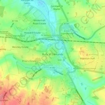
Nome: Mappa topografica Bury St Edmunds, altitudine, rilievo.
Luogo: Bury St Edmunds, West Suffolk, Suffolk, England, United Kingdom (52.22234 0.67387 52.27133 0.76382)
Altitudine media: 54 m
Altitudine minima: 24 m
Altitudine massima: 98 m
The name Bury is etymologically connected with borough, which has cognates in other Germanic languages such as German Burg 'fortress, castle' and Bereich '(defined) area' Old Norse borg 'wall, castle'; and Gothic baurg 'city'. They all derive from Proto-Germanic *burgs 'fortress'. This in turn derives from the Proto-Indo-European root *bhrgh 'fortified elevation', with cognates including Welsh bera 'stack' and Sanskrit bhrant- 'high, elevated building'.
Altre mappe topografiche
Clicca su una mappa per visualizzarne la topografia, l'altitudine e il rilievo.
Newmarket
United Kingdom > England > Suffolk > West Suffolk
Newmarket, West Suffolk, Suffolk, England, United Kingdom
Altitudine media: 45 m
Hargrave
United Kingdom > England > Suffolk > West Suffolk
Hargrave, West Suffolk, Suffolk, England, United Kingdom
Altitudine media: 108 m