
Fai una donazione
Preparati per la tua prossima avventura:
In qualità di associato Amazon, questo sito riceve una commissione sugli acquisti idonei senza alcun costo aggiuntivo per te.
Mappa topografica Knapton
Clicca sulla mappa per visualizzare l'altitudine.
Fai una donazione
Preparati per la tua prossima avventura:
In qualità di associato Amazon, questo sito riceve una commissione sugli acquisti idonei senza alcun costo aggiuntivo per te.
Knapton
The present church dates from mainly the 14th century. The tower is set into the north west corner of the building. The porch is on the southern elevation. Atop of the church there is a weathervane designed by J.S. Cotman an artist famed as a member of the Norwich school. Inside there is a 13th-century font on three high steps which has a Purbeck marble bowl and a cover over which dates from 1704. The inscription which is in Greek reads "wash my sins and not my face only" The inscription is a palindrome, reading the same backwards as forwards.. At the back of the church behind the font there are some coffin-lids from the earlier church set into the flags of the floor. The most prominent feature of this church is the roof. The roof was given to the church by a John Smithe in 1504. It is of a double hammerbeam construction and still retains its original colour. The beams and spandrels are richly carved with three tiers of angels which have outspread wings. More angels are carved on the kingposts and on the wall plate. In niches below the wall supports there are figures with scrolls, shields, symbols or playing musical instruments. The church is a Grade I listed building.
Fai una donazione
Preparati per la tua prossima avventura:
In qualità di associato Amazon, questo sito riceve una commissione sugli acquisti idonei senza alcun costo aggiuntivo per te.
A proposito di questa mappa
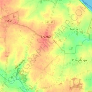
Nome: Mappa topografica Knapton, altitudine, rilievo.
Luogo: Knapton, North Norfolk, Norfolk, England, United Kingdom (52.83071 1.39914 52.87126 1.43681)
Altitudine media: 29 m
Altitudine minima: 0 m
Altitudine massima: 46 m
Fai una donazione
Preparati per la tua prossima avventura:
In qualità di associato Amazon, questo sito riceve una commissione sugli acquisti idonei senza alcun costo aggiuntivo per te.
Altre mappe topografiche
Clicca su una mappa per visualizzarne la topografia, l'altitudine e il rilievo.
Beacon Hill
United Kingdom > England > Norfolk > North Norfolk
Beacon Hill is a part of the Cromer Ridge which is a ridge of old glacial moraines (terminal moraine) that stands next to the coast above Cromer. The Cromer Ridge seems to have been the front line of the ice sheet for some time at the last glaciations, which is shown by the large size of the feature. All the…
Altitudine media: 65 m
Fai una donazione
Preparati per la tua prossima avventura:
In qualità di associato Amazon, questo sito riceve una commissione sugli acquisti idonei senza alcun costo aggiuntivo per te.
Stalham Green
United Kingdom > England > Norfolk > North Norfolk > Stalham Green
Altitudine media: 5 m
Sheringham Park
United Kingdom > England > Norfolk > North Norfolk > Upper Sheringham
Altitudine media: 61 m
Johnson Street
United Kingdom > England > Norfolk > North Norfolk > Ludham > Johnson Street
Altitudine media: 3 m
Fai una donazione
Preparati per la tua prossima avventura:
In qualità di associato Amazon, questo sito riceve una commissione sugli acquisti idonei senza alcun costo aggiuntivo per te.
Fai una donazione
Preparati per la tua prossima avventura:
In qualità di associato Amazon, questo sito riceve una commissione sugli acquisti idonei senza alcun costo aggiuntivo per te.
North Walsham and Dilham Canal
United Kingdom > England > Norfolk > North Norfolk > Honing
Altitudine media: 21 m
Fai una donazione
Preparati per la tua prossima avventura:
In qualità di associato Amazon, questo sito riceve una commissione sugli acquisti idonei senza alcun costo aggiuntivo per te.
Ridlington
United Kingdom > England > Norfolk > North Norfolk > Witton and Ridlington
Altitudine media: 9 m
Fai una donazione
Preparati per la tua prossima avventura:
In qualità di associato Amazon, questo sito riceve una commissione sugli acquisti idonei senza alcun costo aggiuntivo per te.
Fai una donazione
Preparati per la tua prossima avventura:
In qualità di associato Amazon, questo sito riceve una commissione sugli acquisti idonei senza alcun costo aggiuntivo per te.
Whimpwell Green
United Kingdom > England > Norfolk > North Norfolk > Happisburgh
Altitudine media: 4 m
Beeston Bump
United Kingdom > England > Norfolk > North Norfolk > Sheringham > Beeston Regis
Altitudine media: 20 m
Fai una donazione
Preparati per la tua prossima avventura:
In qualità di associato Amazon, questo sito riceve una commissione sugli acquisti idonei senza alcun costo aggiuntivo per te.
Newgate
United Kingdom > England > Norfolk > North Norfolk > Cley next the Sea > Newgate
Altitudine media: 22 m
Bacton Green
United Kingdom > England > Norfolk > North Norfolk > Bacton > Bacton Green
Altitudine media: 9 m
Fai una donazione
Preparati per la tua prossima avventura:
In qualità di associato Amazon, questo sito riceve una commissione sugli acquisti idonei senza alcun costo aggiuntivo per te.