
Fai una donazione
Preparati per la tua prossima avventura:
In qualità di associato Amazon, questo sito riceve una commissione sugli acquisti idonei senza alcun costo aggiuntivo per te.
Mappa topografica Round Mountain
Clicca sulla mappa per visualizzare l'altitudine.
Fai una donazione
Preparati per la tua prossima avventura:
In qualità di associato Amazon, questo sito riceve una commissione sugli acquisti idonei senza alcun costo aggiuntivo per te.
A proposito di questa mappa
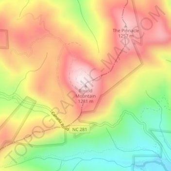
Nome: Mappa topografica Round Mountain, altitudine, rilievo.
Altitudine media: 1.075 m
Altitudine minima: 828 m
Altitudine massima: 1.281 m
Fai una donazione
Preparati per la tua prossima avventura:
In qualità di associato Amazon, questo sito riceve una commissione sugli acquisti idonei senza alcun costo aggiuntivo per te.
Altre mappe topografiche
Clicca su una mappa per visualizzarne la topografia, l'altitudine e il rilievo.
Gorges State Park
United States > North Carolina > Transylvania County
Following the flood, local citizens eventually sold large land tracts in the Gorges to Singer Sewing Machine Company, which logged most of the land. Then, in the 1940s and 1950s, Singer sold the land to Duke Energy Corporation. The corporation purchased the land for its steep topography and high rainfall,…
Altitudine media: 682 m
Fai una donazione
Preparati per la tua prossima avventura:
In qualità di associato Amazon, questo sito riceve una commissione sugli acquisti idonei senza alcun costo aggiuntivo per te.
Dupont State Recreational Forest
United States > North Carolina > Transylvania County
Altitudine media: 840 m
Dupont State Recreational Forest
United States > North Carolina > Transylvania County
Altitudine media: 826 m
Fai una donazione
Preparati per la tua prossima avventura:
In qualità di associato Amazon, questo sito riceve una commissione sugli acquisti idonei senza alcun costo aggiuntivo per te.
Pisgah National Forest
United States > North Carolina > Transylvania County
The Pisgah National Forest covers 512,758 acres (801 sq mi; 2,075 km2) of mountainous terrain in the southern Appalachian Mountains, including parts of the Blue Ridge Mountains and Great Balsam Mountains. Elevations reach over 6,000 feet (1,800 m) and include some of the highest mountains in the eastern United…
Altitudine media: 752 m
Fai una donazione
Preparati per la tua prossima avventura:
In qualità di associato Amazon, questo sito riceve una commissione sugli acquisti idonei senza alcun costo aggiuntivo per te.