
Mappa topografica Urfeld
Clicca sulla mappa per visualizzare l'altitudine.
A proposito di questa mappa
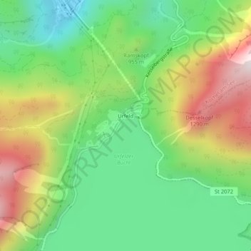
Nome: Mappa topografica Urfeld, altitudine, rilievo.
Altitudine media: 917 m
Altitudine minima: 611 m
Altitudine massima: 1.392 m
Altre mappe topografiche
Clicca su una mappa per visualizzarne la topografia, l'altitudine e il rilievo.
Herzogstand
Deutschland > Bayern > Landkreis Bad Tölz-Wolfratshausen > Kochel am See
Der Herzogstand ist ein Berg in den Bayerischen Voralpen mit 1731 m ü. NHN nordwestlich des Walchensees. Er gehört zum Gebiet der Gemeinde Kochel am See und bildet mit seinem Nachbarn Heimgarten einen Höhenzug, der dem Estergebirge vorgelagert ist und nach Norden in das Bayerische Alpenvorland abfällt.
Altitudine media: 1.237 m