
Fai una donazione
Preparati per la tua prossima avventura:
In qualità di associato Amazon, questo sito riceve una commissione sugli acquisti idonei senza alcun costo aggiuntivo per te.
Mappa topografica Waikanae
Clicca sulla mappa per visualizzare l'altitudine.
Fai una donazione
Preparati per la tua prossima avventura:
In qualità di associato Amazon, questo sito riceve una commissione sugli acquisti idonei senza alcun costo aggiuntivo per te.
A proposito di questa mappa
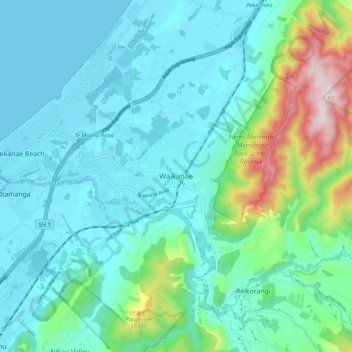
Nome: Mappa topografica Waikanae, altitudine, rilievo.
Altitudine media: 112 m
Altitudine minima: 0 m
Altitudine massima: 587 m
Fai una donazione
Preparati per la tua prossima avventura:
In qualità di associato Amazon, questo sito riceve una commissione sugli acquisti idonei senza alcun costo aggiuntivo per te.
Altre mappe topografiche
Clicca su una mappa per visualizzarne la topografia, l'altitudine e il rilievo.
Kapiti Island
New Zealand > Wellington > Kapiti Coast District
The full original name for the island is Te Waewae-Kapiti-o-Tara-rāua-ko-Rangitāne, meaning "the boundary of Tara and Rangitāne" and referring to it as a place where the rohe (territories) of Ngāi Tara (now known as Muaūpoko) and Rangitāne (descendents of Whātonga) iwi adjoined each other. The word…
Altitudine media: 55 m
Fai una donazione
Preparati per la tua prossima avventura:
In qualità di associato Amazon, questo sito riceve una commissione sugli acquisti idonei senza alcun costo aggiuntivo per te.
Kapiti Island
New Zealand > Wellington > Kapiti Coast District
The full original name for the island, Ko te Waewae-Kapiti-o-Tara-rāua-ko-Rangitāne, meaning "the boundary of Tara and Rangitāne", refers to it as a place where the rohe (territories) of Ngāi Tara (now known as Muaūpoko) and Rangitāne iwi adjoined each other. The word kapiti (to be joined) is spelt…
Altitudine media: 55 m