
Fai una donazione
Preparati per la tua prossima avventura:
In qualità di associato Amazon, questo sito riceve una commissione sugli acquisti idonei senza alcun costo aggiuntivo per te.
Mappa topografica Anthony
Clicca sulla mappa per visualizzare l'altitudine.
Fai una donazione
Preparati per la tua prossima avventura:
In qualità di associato Amazon, questo sito riceve una commissione sugli acquisti idonei senza alcun costo aggiuntivo per te.
Anthony
Anthony has a desert climate, with a high degree of diurnal temperature variation due to the relatively high elevation and aridity.
Fai una donazione
Preparati per la tua prossima avventura:
In qualità di associato Amazon, questo sito riceve una commissione sugli acquisti idonei senza alcun costo aggiuntivo per te.
A proposito di questa mappa
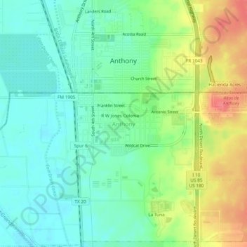
Nome: Mappa topografica Anthony, altitudine, rilievo.
Luogo: Anthony, El Paso County, Texas, 79821, United States (31.97565 -106.61682 32.01565 -106.57682)
Altitudine media: 1.173 m
Altitudine minima: 1.147 m
Altitudine massima: 1.220 m
Fai una donazione
Preparati per la tua prossima avventura:
In qualità di associato Amazon, questo sito riceve una commissione sugli acquisti idonei senza alcun costo aggiuntivo per te.
Altre mappe topografiche
Clicca su una mappa per visualizzarne la topografia, l'altitudine e il rilievo.
El Paso
United States > Texas > El Paso County
El Paso is characterized by a diverse and striking topography shaped by its desert environment and mountainous landscapes. The city is situated at an average elevation of approximately 3,700 feet above sea level, surrounded by the rugged Franklin Mountains to the west, where peaks exceed 7,000 feet. This…
Altitudine media: 1.237 m
El Paso
United States > Texas > El Paso County
El Paso County was established in March 1850, with San Elizario as the first county seat. The United States Senate fixed a boundary between Texas and New Mexico at the 32nd parallel, thus largely ignoring history and topography. A military post called the "Post opposite El Paso" (meaning opposite El Paso del…
Altitudine media: 1.237 m
Anthony
United States > Texas > El Paso County
Anthony has a desert climate, with a high degree of diurnal temperature variation due to the relatively high elevation and aridity.
Altitudine media: 1.176 m
Fai una donazione
Preparati per la tua prossima avventura:
In qualità di associato Amazon, questo sito riceve una commissione sugli acquisti idonei senza alcun costo aggiuntivo per te.
El Paso
United States > Texas > El Paso County
El Paso County was established in March 1850, with San Elizario as the first county seat. The United States Senate fixed a boundary between Texas and New Mexico at the 32nd parallel, thus largely ignoring history and topography. A military post called the "Post opposite El Paso" (meaning opposite El Paso del…
Altitudine media: 1.237 m
Fai una donazione
Preparati per la tua prossima avventura:
In qualità di associato Amazon, questo sito riceve una commissione sugli acquisti idonei senza alcun costo aggiuntivo per te.
El Paso
United States > Texas > El Paso County
El Paso County was established in March 1850, with San Elizario as the first county seat. The United States Senate fixed a boundary between Texas and New Mexico at the 32nd parallel, thus largely ignoring history and topography. A military post called the "Post opposite El Paso" (meaning opposite El Paso del…
Altitudine media: 1.237 m
El Paso
United States > Texas > El Paso County
El Paso County was established in March 1850, with San Elizario as the first county seat. The United States Senate fixed a boundary between Texas and New Mexico at the 32nd parallel, thus largely ignoring history and topography. A military post called the "Post opposite El Paso" (meaning opposite El Paso del…
Altitudine media: 1.237 m
Fai una donazione
Preparati per la tua prossima avventura:
In qualità di associato Amazon, questo sito riceve una commissione sugli acquisti idonei senza alcun costo aggiuntivo per te.
Mc Arthur Park
United States > Texas > El Paso County > El Paso > Cielo Vista
Altitudine media: 1.199 m
El Paso
United States > Texas > El Paso County
El Paso County was established in March 1850, with San Elizario as the first county seat. The United States Senate fixed a boundary between Texas and New Mexico at the 32nd parallel, thus largely ignoring history and topography. A military post called the "Post opposite El Paso" (meaning opposite El Paso del…
Altitudine media: 1.237 m
Fai una donazione
Preparati per la tua prossima avventura:
In qualità di associato Amazon, questo sito riceve una commissione sugli acquisti idonei senza alcun costo aggiuntivo per te.