
Fai una donazione
Preparati per la tua prossima avventura:
In qualità di associato Amazon, questo sito riceve una commissione sugli acquisti idonei senza alcun costo aggiuntivo per te.
Mappa topografica Marlborough District
Clicca sulla mappa per visualizzare l'altitudine.
Fai una donazione
Preparati per la tua prossima avventura:
In qualità di associato Amazon, questo sito riceve una commissione sugli acquisti idonei senza alcun costo aggiuntivo per te.
A proposito di questa mappa
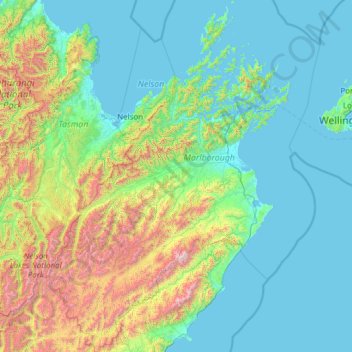
Nome: Mappa topografica Marlborough District, altitudine, rilievo.
Luogo: Marlborough District, Marlborough, New Zealand (-42.48813 172.71853 -40.66131 174.44288)
Altitudine media: 408 m
Altitudine minima: 0 m
Altitudine massima: 2.754 m
Fai una donazione
Preparati per la tua prossima avventura:
In qualità di associato Amazon, questo sito riceve una commissione sugli acquisti idonei senza alcun costo aggiuntivo per te.
Altre mappe topografiche
Clicca su una mappa per visualizzarne la topografia, l'altitudine e il rilievo.
Picton
New Zealand > Marlborough > Marlborough District
On the land side, Picton is surrounded by hills and mountains, including Te Tara-o-Te-Marama/Mount Freeth to the west, the Robertson Range to the south and Mount McCormick to the east. The Elevation Saddle connects southwest of the town with the Tuamarina River valley and contains the main land transport…
Altitudine media: 193 m
Fai una donazione
Preparati per la tua prossima avventura:
In qualità di associato Amazon, questo sito riceve una commissione sugli acquisti idonei senza alcun costo aggiuntivo per te.
Saint Arnaud Range
New Zealand > Marlborough > Marlborough District
The lower elevations are covered primarily in beech forests, while higher elevations (above about 5,000 feet) are alpine.
Altitudine media: 1.249 m
Fai una donazione
Preparati per la tua prossima avventura:
In qualità di associato Amazon, questo sito riceve una commissione sugli acquisti idonei senza alcun costo aggiuntivo per te.
Fai una donazione
Preparati per la tua prossima avventura:
In qualità di associato Amazon, questo sito riceve una commissione sugli acquisti idonei senza alcun costo aggiuntivo per te.
Fai una donazione
Preparati per la tua prossima avventura:
In qualità di associato Amazon, questo sito riceve una commissione sugli acquisti idonei senza alcun costo aggiuntivo per te.
Fai una donazione
Preparati per la tua prossima avventura:
In qualità di associato Amazon, questo sito riceve una commissione sugli acquisti idonei senza alcun costo aggiuntivo per te.
Saint Arnaud Range
New Zealand > Marlborough > Marlborough District
The lower elevations are covered primarily in beech forests, while higher elevations (above about 5,000 feet) are alpine.
Altitudine media: 1.249 m
Picton
New Zealand > Marlborough > Marlborough District
On the land side, Picton is surrounded by hills and mountains, including Te Tara-o-Te-Marama/Mount Freeth to the west, the Robertson Range to the south and Mount McCormick to the east. The Elevation Saddle connects southwest of the town with the Tuamarina River valley and contains the main land transport…
Altitudine media: 193 m
Fai una donazione
Preparati per la tua prossima avventura:
In qualità di associato Amazon, questo sito riceve una commissione sugli acquisti idonei senza alcun costo aggiuntivo per te.
Fai una donazione
Preparati per la tua prossima avventura:
In qualità di associato Amazon, questo sito riceve una commissione sugli acquisti idonei senza alcun costo aggiuntivo per te.