
Fai una donazione
Preparati per la tua prossima avventura:
In qualità di associato Amazon, questo sito riceve una commissione sugli acquisti idonei senza alcun costo aggiuntivo per te.
Mappa topografica Lone Peak Wilderness
Clicca sulla mappa per visualizzare l'altitudine.
Fai una donazione
Preparati per la tua prossima avventura:
In qualità di associato Amazon, questo sito riceve una commissione sugli acquisti idonei senza alcun costo aggiuntivo per te.
Lone Peak Wilderness
The Lone Peak Wilderness provides a spectacular backdrop for the growing urban areas along the Wasatch Front and is dominated by rugged terrain, narrow canyons and high peaks, including the Pfeifferhorn, commonly referred to as Little Matterhorn Peak, at 11,326 feet (3,452 m) and Lone Peak at 11,253 feet (3,430 meters). The geologic structure of the area is varied and complex, consisting of granitoid rock masses and several sedimentary formations. Carving of the present alpine topography is due to glaciation, with erosion being the current dominant force in the land sculpturing process. Much of the higher elevation is alpine, characterized by large, open cirque basins and exposed rocky ridges. A few small natural and reservoired lakes add to the scenic beauty.
Fai una donazione
Preparati per la tua prossima avventura:
In qualità di associato Amazon, questo sito riceve una commissione sugli acquisti idonei senza alcun costo aggiuntivo per te.
A proposito di questa mappa
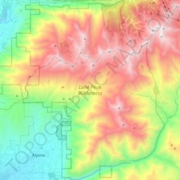
Nome: Mappa topografica Lone Peak Wilderness, altitudine, rilievo.
Altitudine media: 2.367 m
Altitudine minima: 1.464 m
Altitudine massima: 3.480 m
Fai una donazione
Preparati per la tua prossima avventura:
In qualità di associato Amazon, questo sito riceve una commissione sugli acquisti idonei senza alcun costo aggiuntivo per te.