
Fai una donazione
Preparati per la tua prossima avventura:
In qualità di associato Amazon, questo sito riceve una commissione sugli acquisti idonei senza alcun costo aggiuntivo per te.
Mappa topografica Saxtons River
Clicca sulla mappa per visualizzare l'altitudine.
Fai una donazione
Preparati per la tua prossima avventura:
In qualità di associato Amazon, questo sito riceve una commissione sugli acquisti idonei senza alcun costo aggiuntivo per te.
Saxtons River
The Saxtons River is a 22.9-mile-long (36.9 km) river in the U.S. state of Vermont, a tributary of the Connecticut River. Its watershed covers 78 square miles (200 km2) and a range in altitude of 1,800 feet (550 m); land use is about 80% forested and 3% agricultural, and the upper river supports wild brook trout and brown trout, while Atlantic salmon occur but are usually limited to the area below Twin Falls on the lower river.
Fai una donazione
Preparati per la tua prossima avventura:
In qualità di associato Amazon, questo sito riceve una commissione sugli acquisti idonei senza alcun costo aggiuntivo per te.
A proposito di questa mappa
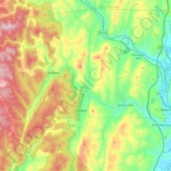
Nome: Mappa topografica Saxtons River, altitudine, rilievo.
Altitudine media: 321 m
Altitudine minima: 66 m
Altitudine massima: 689 m
Fai una donazione
Preparati per la tua prossima avventura:
In qualità di associato Amazon, questo sito riceve una commissione sugli acquisti idonei senza alcun costo aggiuntivo per te.