
Fai una donazione
Preparati per la tua prossima avventura:
In qualità di associato Amazon, questo sito riceve una commissione sugli acquisti idonei senza alcun costo aggiuntivo per te.
Mappa topografica Camelback Mountain
Clicca sulla mappa per visualizzare l'altitudine.
Fai una donazione
Preparati per la tua prossima avventura:
In qualità di associato Amazon, questo sito riceve una commissione sugli acquisti idonei senza alcun costo aggiuntivo per te.
Camelback Mountain
Efforts to protect Camelback Mountain as a natural preserve began in the early 1910s. However, by the 1960s, nearly all of the area had been sold to private interests. Federal and state authorities attempted to stop development above the one thousand and six hundred feet level. They failed to halt development and in 1963 efforts to arrange a land exchange failed in the Arizona State legislature. In 1965, United States Senator Barry Goldwater took up the cause and helped to secure the higher elevations against development. The area became a Phoenix city park in 1968.
Fai una donazione
Preparati per la tua prossima avventura:
In qualità di associato Amazon, questo sito riceve una commissione sugli acquisti idonei senza alcun costo aggiuntivo per te.
A proposito di questa mappa
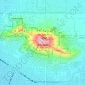
Nome: Mappa topografica Camelback Mountain, altitudine, rilievo.
Altitudine media: 463 m
Altitudine minima: 389 m
Altitudine massima: 798 m
Fai una donazione
Preparati per la tua prossima avventura:
In qualità di associato Amazon, questo sito riceve una commissione sugli acquisti idonei senza alcun costo aggiuntivo per te.
Altre mappe topografiche
Clicca su una mappa per visualizzarne la topografia, l'altitudine e il rilievo.
Fai una donazione
Preparati per la tua prossima avventura:
In qualità di associato Amazon, questo sito riceve una commissione sugli acquisti idonei senza alcun costo aggiuntivo per te.