
Mappa topografica Imphal East
Mappa interattiva
Clicca sulla mappa per visualizzare l'altitudine.
A proposito di questa mappa
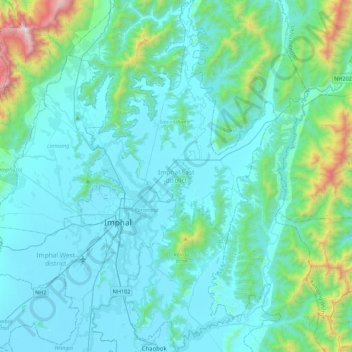
Nome: Mappa topografica Imphal East, altitudine, rilievo.
Luogo: Imphal East, Manipur, India (24.65151 93.89542 25.05120 94.13485)
Altitudine media: 982 m
Altitudine minima: 767 m
Altitudine massima: 2.498 m
Imphal East District came into existence on 18-06-1997 with its headquarters at Porompat occupying the eastern part of Imphal District. The total area of District is 497 km2. approximately. The District is situated at an altitude 790 metres above the M.S. Level. The climate of the District is salubrious and Monsoon is tropical. The minimum temperature goes down to 0.6 degree Celsius in winter and 41 degree Celsius in summer. It has no rail network and hence communication is entirely dependent on roads except Jiribam District bordering Cachar District of Assam where there is a railhead. As of 2017, A new rail line is under construction and a railway station will be operational by 2019. The District is connected with N.H. 39, N.H. 53 and N.H. 150.
Altre mappe topografiche
Clicca su una mappa per visualizzarne la topografia, l'altitudine e il rilievo.
Senapati
India > Manipur > Senapati tehsil
Senapati, Senapati tehsil, Senapati District, Manipur, India
Altitudine media: 1.321 m
Loktak Lake
India > Manipur > Bishnupur > Moirang
Loktak Lake, Moirang, Bishnupur, Manipur, India
Altitudine media: 771 m
Chingmai Khullen
Chingmai Khullen, Paomata, Senapati, Manipur, India
Altitudine media: 1.454 m
Nambul River
Nambul River, Imphal, Lamphelpat, Imphal West, Manipur, 795001, India
Altitudine media: 779 m
Khuga Dam
India > Manipur > Churachandpur
Khuga Dam, Churachandpur, Manipur, India
Altitudine media: 849 m
Ningthoukhong
India > Manipur > Ningthoukhong
Ningthoukhong, Moirang, Bishnupur, Manipur, 795126, India
Altitudine media: 777 m
Imphal
India > Manipur > Lamphelpat
Imphal, Lamphelpat, Imphal West, Manipur, 795001, India
Altitudine media: 861 m