

Mappa topografica Bolton
Clicca sulla mappa per visualizzare l'altitudine.
A proposito di questa mappa
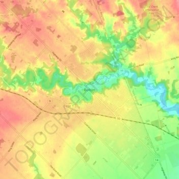
Nome: Mappa topografica Bolton, altitudine, rilievo.
Luogo: Bolton, Caledon, Peel Region, Ontario, L7E 1C8, Canada (43.83955 -79.77826 43.91955 -79.69826)
Altitudine media: 250 m
Altitudine minima: 200 m
Altitudine massima: 289 m
Altre mappe topografiche
Clicca su una mappa per visualizzarne la topografia, l'altitudine e il rilievo.
Mississauga
Canada > Ontario > Peel Region
The shoreline of former Glacial Lake Iroquois roughly follows the Dundas Street alignment, although it is not noticeable in some places but is more prominent in others, such as the site of the former brickyard (Shoreline Dr. near Mavis Rd.), the ancient shoreline promenteau affords a clear view of downtown…
Altitudine media: 151 m


Mississauga
Canada > Ontario > Peel Region
The shoreline of former Glacial Lake Iroquois roughly follows the Dundas Street alignment, although it is not noticeable in some places but is more prominent in others, such as the site of the former brickyard (Shoreline Dr. near Mavis Rd.). The ancient shoreline promontory affords a clear view of downtown…
Altitudine media: 151 m
Mississauga
Canada > Ontario > Peel Region
The shoreline of former Glacial Lake Iroquois roughly follows the Dundas Street alignment, although it is not noticeable in some places but is more prominent in others, such as the site of the former brickyard (Shoreline Dr. near Mavis Rd.), the ancient shoreline promenteau affords a clear view of downtown…
Altitudine media: 151 m
Mississauga
Canada > Ontario > Peel Region
The shoreline of former Glacial Lake Iroquois roughly follows the Dundas Street alignment, although it is not noticeable in some places but is more prominent in others, such as the site of the former brickyard (Shoreline Dr. near Mavis Rd.). The ancient shoreline promontory affords a clear view of downtown…
Altitudine media: 151 m

Mississauga
Canada > Ontario > Peel Region
The shoreline of former Glacial Lake Iroquois roughly follows the Dundas Street alignment, although it is not noticeable in some places but is more prominent in others, such as the site of the former brickyard (Shoreline Dr. near Mavis Rd.), the ancient shoreline promenteau affords a clear view of downtown…
Altitudine media: 151 m
Mississauga
Canada > Ontario > Peel Region
The shoreline of former Glacial Lake Iroquois roughly follows the Dundas Street alignment, although it is not noticeable in some places but is more prominent in others, such as the site of the former brickyard (Shoreline Dr. near Mavis Rd.). The ancient shoreline promontory affords a clear view of downtown…
Altitudine media: 151 m
Mississauga
Canada > Ontario > Peel Region
The shoreline of former Glacial Lake Iroquois roughly follows the Dundas Street alignment, although it is not noticeable in some places but is more prominent in others, such as the site of the former brickyard (Shoreline Dr. near Mavis Rd.). The ancient shoreline promontory affords a clear view of downtown…
Altitudine media: 151 m
Mississauga
Canada > Ontario > Peel Region
The shoreline of former Glacial Lake Iroquois roughly follows the Dundas Street alignment, although it is not noticeable in some places but is more prominent in others, such as the site of the former brickyard (Shoreline Dr. near Mavis Rd.), the ancient shoreline promenteau affords a clear view of downtown…
Altitudine media: 151 m
Mississauga
Canada > Ontario > Peel Region
The shoreline of former Glacial Lake Iroquois roughly follows the Dundas Street alignment, although it is not noticeable in some places but is more prominent in others, such as the site of the former brickyard (Shoreline Dr. near Mavis Rd.), the ancient shoreline promenteau affords a clear view of downtown…
Altitudine media: 151 m