
Mappa topografica Asheville
Clicca sulla mappa per visualizzare l'altitudine.
Asheville
Asheville has a humid subtropical climate (Köppen Cfa), resembling the rest of the Piedmont region of the southeastern U.S., but with noticeably cooler temperatures due to the higher elevation; it is part of USDA Hardiness zone 7a. The area's summers in particular, though warm, are not as hot as summers in cities farther east in the state, as the July daily average temperature is 73.8 °F (23.2 °C) and there is an average of only 9.4 days with 90 °F (32 °C)+ highs annually; The last time a calendar year passed without a 90 °F reading was 2009. Moreover, warm nights where the low remains at or above 70 °F (21 °C) are much less common than 90 °F temperatures. Winters are cool, with a January daily average of 37.1 °F (2.8 °C) and highs remaining at or below freezing on 5.5 days.
A proposito di questa mappa
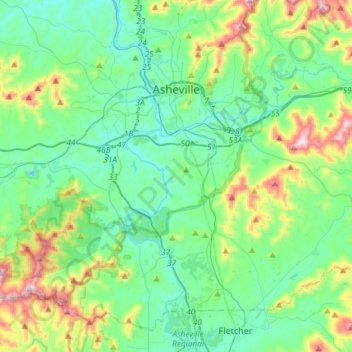
Nome: Mappa topografica Asheville, altitudine, rilievo.
Luogo: Asheville, Buncombe County, North Carolina, United States (35.41646 -82.67036 35.65608 -82.46047)
Altitudine media: 727 m
Altitudine minima: 578 m
Altitudine massima: 1.209 m
Altre mappe topografiche
Clicca su una mappa per visualizzarne la topografia, l'altitudine e il rilievo.
Haw Creek Park
United States > North Carolina > Buncombe County > Asheville > Dogwood Grove
Altitudine media: 666 m
Arden
United States > North Carolina > Buncombe County > Asheville > Royal Pines
Altitudine media: 693 m
Royal Pines
United States > North Carolina > Buncombe County > Asheville
Royal Pines is located in southern Buncombe County at 35°28′39″N 82°30′35″W / 35.47750°N 82.50972°W / 35.47750; -82.50972 (35.477386, -82.509833). It is bordered to the west by U.S. Route 25A and the city limits of Asheville, and to the northeast by Mills Gap Road. Brown Mountain, with an…
Altitudine media: 700 m
Aston Park
United States > North Carolina > Buncombe County > Asheville > River Arts District
Altitudine media: 641 m