
Fai una donazione
Preparati per la tua prossima avventura:
In qualità di associato Amazon, questo sito riceve una commissione sugli acquisti idonei senza alcun costo aggiuntivo per te.
Mappa topografica Williams
Clicca sulla mappa per visualizzare l'altitudine.
Fai una donazione
Preparati per la tua prossima avventura:
In qualità di associato Amazon, questo sito riceve una commissione sugli acquisti idonei senza alcun costo aggiuntivo per te.
Williams
Williams occupies a high, forested setting in northern Arizona, in the heart of the Kaibab National Forest at about 6,770 feet (2,063 m) above sea level, where broad plateau surfaces, shallow drainage corridors, and low volcanic hills give the town a gently undulating upland character. Its most prominent relief is immediately to the south, where Bill Williams Mountain rises steeply to about 9,260 feet (2,822 m), creating a strong local elevation contrast between the Route 66/I-40 corridor and the surrounding summit terrain. The wider landscape belongs to the volcanic highlands west of Flagstaff, with lava-dome and volcanic-field landforms contributing to the area’s knolls, ridges, and isolated peaks, while ponderosa pine forests, oak thickets, aspen, and fir mark the cooler, higher slopes. Overall, Williams has the physical character of a cool, elevated plateau town set among volcanic uplands, with open forested flats and rolling hills giving way to rugged mountain relief along its southern edge.
Fai una donazione
Preparati per la tua prossima avventura:
In qualità di associato Amazon, questo sito riceve una commissione sugli acquisti idonei senza alcun costo aggiuntivo per te.
A proposito di questa mappa
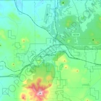
Nome: Mappa topografica Williams, altitudine, rilievo.
Luogo: Williams, Coconino County, Arizona, 86046, United States (35.18978 -112.24731 35.32272 -112.10644)
Altitudine media: 2.131 m
Altitudine minima: 1.962 m
Altitudine massima: 2.811 m
Fai una donazione
Preparati per la tua prossima avventura:
In qualità di associato Amazon, questo sito riceve una commissione sugli acquisti idonei senza alcun costo aggiuntivo per te.
Altre mappe topografiche
Clicca su una mappa per visualizzarne la topografia, l'altitudine e il rilievo.
Flagstaff
United States > Arizona > Coconino County
Flagstaff is the county seat of Coconino County. According to the United States Census Bureau, the city has a total area of 63.9 square miles (165.5 km2), of which only 0.03 square miles (0.08 km2) (0.08%) is water. Flagstaff lies at approximately 7,000 feet (2,130 m) elevation, and is surrounded by the…
Altitudine media: 2.176 m