
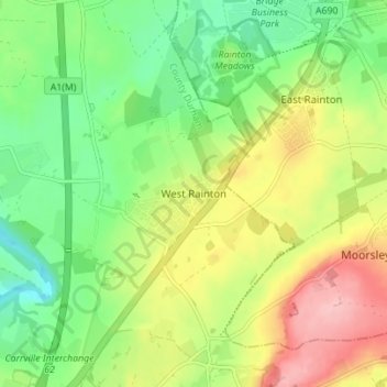
Mappa topografica West Rainton
Mappa interattiva
Clicca sulla mappa per visualizzare l'altitudine.
A proposito di questa mappa
Nome: Mappa topografica West Rainton, altitudine, rilievo.
Altitudine media: 79 m
Altitudine minima: 20 m
Altitudine massima: 162 m
The following is from History, Topography and Directory of Durham, Whellan, London, 1894; "The village of West Rainton is about four miles north-east of Durham, and formerly contained an ancient chapel with chantry dedicated to the Virgin Mary; some of the old stones may be seen in the different buildings in the village. The Old Hall, situated in the centre of the village, was built about 1690, by Sir Jno. Buck, [sic] now in a state of dilapidation, and let in tenements occupied by pitmen. There is a library, reading, and news-room here. There are two batteries of the Second Durham Artillery Volunteers, having a drill-hall here, built by the Marquess of Londonderry in 1880, the headquarters being at Seaham Harbour."[6]
Altre mappe topografiche
Clicca su una mappa per visualizzarne la topografia, l'altitudine e il rilievo.
Coxhoe
United Kingdom > England > County Durham
Coxhoe, County Durham, North East, England, United Kingdom
Altitudine media: 111 m
Consett
United Kingdom > England > County Durham
Consett, County Durham, North East, England, United Kingdom
Altitudine media: 205 m
Wycliffe
United Kingdom > England > County Durham
Wycliffe, Wycliffe with Thorpe, County Durham, North East, England, DL12 9TS, United Kingdom
Altitudine media: 129 m
Flint Hill
United Kingdom > England > County Durham
Flint Hill, County Durham, North East, England, DH9 9JW, United Kingdom
Altitudine media: 191 m
Bearpark
United Kingdom > England > County Durham > Bearpark
Bearpark, County Durham, North East, England, United Kingdom
Altitudine media: 106 m
Thornberry
United Kingdom > England > County Durham
Thornberry, Boldron, County Durham, North East, England, DL12 9JJ, United Kingdom
Altitudine media: 255 m
Seaham
United Kingdom > England > County Durham
Seaham, County Durham, North East, England, United Kingdom
Altitudine media: 31 m
Darlington
United Kingdom > England > County Durham
Darlington, County Durham, Tees Valley, England, DL1 5PW, United Kingdom
Altitudine media: 52 m
Tyne and Wear
United Kingdom > England > County Durham
Tyne and Wear, County Durham, North East, England, United Kingdom
Altitudine media: 82 m
Toronto
United Kingdom > England > County Durham > Toronto
Toronto, County Durham, North East, England, DL14 7RX, United Kingdom
Altitudine media: 107 m
Langton
United Kingdom > England > County Durham > Langton
Langton, County Durham, North East England, England, United Kingdom
Altitudine media: 105 m