
Mappa topografica Kampung Janda Baik
Mappa interattiva
Clicca sulla mappa per visualizzare l'altitudine.
A proposito di questa mappa
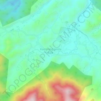
Nome: Mappa topografica Kampung Janda Baik, altitudine, rilievo.
Luogo: Kampung Janda Baik, Bentong, Pahang, 28750, Malaysia (3.30276 101.82868 3.34276 101.86868)
Altitudine media: 501 m
Altitudine minima: 351 m
Altitudine massima: 895 m
Before Janda Baik was founded in 1930, the area was primarily inhabited by Orang Asli tribes. The village was founded when some residents moved from Bentong to an area with a higher elevation due to the 1926 floods that affected Bentong and other low elevation areas. The earliest founders for this village are Haji Deris, Haji Kadir, and Haji Yasir, who built a hut and stayed in the area for almost a week before others start to populate the area. The village was originally given the name Kampung Tiga Haji to refer to the three early settlers.
Altre mappe topografiche
Clicca su una mappa per visualizzarne la topografia, l'altitudine e il rilievo.