
Fai una donazione
Preparati per la tua prossima avventura:
In qualità di associato Amazon, questo sito riceve una commissione sugli acquisti idonei senza alcun costo aggiuntivo per te.
Mappa topografica Bald Mountain
Clicca sulla mappa per visualizzare l'altitudine.
Fai una donazione
Preparati per la tua prossima avventura:
In qualità di associato Amazon, questo sito riceve una commissione sugli acquisti idonei senza alcun costo aggiuntivo per te.
A proposito di questa mappa
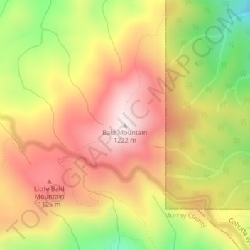
Nome: Mappa topografica Bald Mountain, altitudine, rilievo.
Luogo: Bald Mountain, Murray County, Georgia, United States (34.86445 -84.62836 34.86455 -84.62826)
Altitudine media: 986 m
Altitudine minima: 685 m
Altitudine massima: 1.212 m
Fai una donazione
Preparati per la tua prossima avventura:
In qualità di associato Amazon, questo sito riceve una commissione sugli acquisti idonei senza alcun costo aggiuntivo per te.
Altre mappe topografiche
Clicca su una mappa per visualizzarne la topografia, l'altitudine e il rilievo.
Chatsworth
United States > Georgia > Murray County
Chatsworth is located in central Murray County at 34°46′20″N 84°46′44″W / 34.77222°N 84.77889°W / 34.77222; -84.77889 (34.772336, -84.778977), in northwestern Georgia. It sits at an elevation of 750 feet (230 m) on the west side of the valley of Holly Creek, with 2,840-foot (870 m) Fort…
Altitudine media: 241 m