
Fai una donazione
Preparati per la tua prossima avventura:
In qualità di associato Amazon, questo sito riceve una commissione sugli acquisti idonei senza alcun costo aggiuntivo per te.
Mappa topografica Belgorod
Clicca sulla mappa per visualizzare l'altitudine.
Fai una donazione
Preparati per la tua prossima avventura:
In qualità di associato Amazon, questo sito riceve una commissione sugli acquisti idonei senza alcun costo aggiuntivo per te.
Belgorod
There were several attacks on Belgorod during the Russian invasion of Ukraine. Russian officials claimed that Belgorod was repeatedly targeted by indiscriminate Ukrainian attacks. On 1 April 2022, two Ukrainian Mi-24 performed a night raid and set fire to a fuel depot in Belgorod, in a low-altitude airstrike. On 20 April 2023, a Russian Su-34 fighter jet accidentally dropped a bomb on the city, leaving a crater 20 metres (66 ft) across and injuring two people. On 22 April, more than 3,000 people were evacuated from their homes after an undetonated explosive was found; it was not known if the second bomb had come from the same aircraft. On 30 December, a Ukrainian airstrike killed 25 people and wounded over 100. In March 2024, authorities began evacuating 9,000 children from the city and wider region due to shelling and drone attacks. On 6 May, at least six people were killed following a Ukrainian drone strike. On 12 May, 16 people were killed when a section of an apartment block collapsed. Russian MOD claimed it as a Ukrainian missile strike. CIT investigators said the building was most likely hit by a Russian bomb, as the explosion occurred on the North-Eastern side of the building, opposite to the border with Ukraine.
Fai una donazione
Preparati per la tua prossima avventura:
In qualità di associato Amazon, questo sito riceve una commissione sugli acquisti idonei senza alcun costo aggiuntivo per te.
A proposito di questa mappa
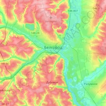
Nome: Mappa topografica Belgorod, altitudine, rilievo.
Altitudine media: 163 m
Altitudine minima: 107 m
Altitudine massima: 227 m
Fai una donazione
Preparati per la tua prossima avventura:
In qualità di associato Amazon, questo sito riceve una commissione sugli acquisti idonei senza alcun costo aggiuntivo per te.