
Fai una donazione
Preparati per la tua prossima avventura:
In qualità di associato Amazon, questo sito riceve una commissione sugli acquisti idonei senza alcun costo aggiuntivo per te.
Mappa topografica Lake Norman
Clicca sulla mappa per visualizzare l'altitudine.
Fai una donazione
Preparati per la tua prossima avventura:
In qualità di associato Amazon, questo sito riceve una commissione sugli acquisti idonei senza alcun costo aggiuntivo per te.
Lake Norman
Lake Norman and the surrounding shoreline serve as a habitat for a diverse array of plants and wildlife, as well as a place for a myriad of human activities. Maintaining this habitat to simultaneously preserve endangered species, keep invasive species at bay, and maintain health and safety standards for the people that live, work, and recreate on the lake is an arduous undertaking. The management of the lake is complicated by the presence of multiple stakeholders in the lake's management, often with conflicting interests and priorities. Duke Energy owns most of the land underneath Lake Norman, as well as the land above the lake up to an elevation of 232 metres (761 ft), with the exception of land platted to other ownership. Certain lakebed portions are owned by families that settled on the banks of the Catawba River prior to the flooding of Norman. Those families allowed Duke Energy to flood their properties, yet the lakebed still remains property of these families. Duke Energy is in charge of management of the lake itself as well as any property, such as lake walls, docks, and beaches, that enter into this zone. The land that falls under the jurisdiction of Duke Energy is subject to the ordinances of the Federal Energy Regulatory Commission, while the land surrounding the lake, both publicly and privately owned, is subject to the ordinances of the state of North Carolina and the county in which the land falls (Catawba County, Iredell County, Lincoln County, or Mecklenburg County). Additionally, the Lake Norman Marine Commission and the North Carolina Wildlife Resources Commission, as well as many non-governmental organizations and environmental organizations, play roles in the regulation and management of the lake. Environmental duties are divided between these different stakeholders, but some fall under split jurisdiction. Water quality, for example, is monitored and managed by both Duke Energy and the state of North Carolina. Other partnerships are voluntary: Duke Energy, for example, partners with many wildlife organizations to minimize the impact of human activities on the environment.
Fai una donazione
Preparati per la tua prossima avventura:
In qualità di associato Amazon, questo sito riceve una commissione sugli acquisti idonei senza alcun costo aggiuntivo per te.
A proposito di questa mappa
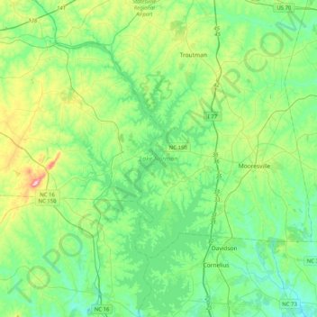
Nome: Mappa topografica Lake Norman, altitudine, rilievo.
Altitudine media: 254 m
Altitudine minima: 187 m
Altitudine massima: 463 m
Fai una donazione
Preparati per la tua prossima avventura:
In qualità di associato Amazon, questo sito riceve una commissione sugli acquisti idonei senza alcun costo aggiuntivo per te.
Altre mappe topografiche
Clicca su una mappa per visualizzarne la topografia, l'altitudine e il rilievo.