
Fai una donazione
Preparati per la tua prossima avventura:
In qualità di associato Amazon, questo sito riceve una commissione sugli acquisti idonei senza alcun costo aggiuntivo per te.
Mappa topografica Mount Crichton
Clicca sulla mappa per visualizzare l'altitudine.
Fai una donazione
Preparati per la tua prossima avventura:
In qualità di associato Amazon, questo sito riceve una commissione sugli acquisti idonei senza alcun costo aggiuntivo per te.
A proposito di questa mappa
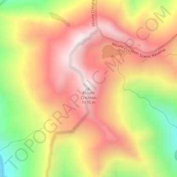
Nome: Mappa topografica Mount Crichton, altitudine, rilievo.
Luogo: Mount Crichton, Queenstown-Lakes District, New Zealand (-45.02724 168.48615 -45.02714 168.48625)
Altitudine media: 1.460 m
Altitudine minima: 921 m
Altitudine massima: 1.849 m
Fai una donazione
Preparati per la tua prossima avventura:
In qualità di associato Amazon, questo sito riceve una commissione sugli acquisti idonei senza alcun costo aggiuntivo per te.
Altre mappe topografiche
Clicca su una mappa per visualizzarne la topografia, l'altitudine e il rilievo.
Pisa Range
New Zealand > Queenstown-Lakes District > Cromwell Community
Elevation ranges from approximately 450 to 1,963 m (1,476 to 6,440 ft) at the highest point. The aerial extent of the range is defined by the Clutha River / Lake Dunstan to the north and east, while the Cardrona River and Kawarau River lie on the western and southern boundaries, respectively.
Altitudine media: 1.253 m
Fai una donazione
Preparati per la tua prossima avventura:
In qualità di associato Amazon, questo sito riceve una commissione sugli acquisti idonei senza alcun costo aggiuntivo per te.
Fai una donazione
Preparati per la tua prossima avventura:
In qualità di associato Amazon, questo sito riceve una commissione sugli acquisti idonei senza alcun costo aggiuntivo per te.
The Remarkables
New Zealand > Queenstown-Lakes District
The area contains a number of beautiful features, such as Lake Alta, a small lake nestled within a natural amphitheatre at the head of a glacial valley (a ‘cirque’) and below the towering Double Cone peaks. There are a number of high altitude walks in the Remarkables Conservation Area including Lake Alta…
Altitudine media: 1.200 m