
Mappa topografica Vijayawada
Clicca sulla mappa per visualizzare l'altitudine.
Vijayawada
Vijayawada lies on the banks of Krishna river, covered by hills and canals. and at an altitude of 11 m (36 ft) above sea level. Three canals originating from the north side of the Prakasam Barrage reservoir — Eluru, Bandar, and Ryves — flow through the city.
A proposito di questa mappa
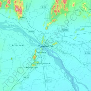
Nome: Mappa topografica Vijayawada, altitudine, rilievo.
Altitudine media: 37 m
Altitudine minima: 7 m
Altitudine massima: 448 m