
Fai una donazione
Preparati per la tua prossima avventura:
In qualità di associato Amazon, questo sito riceve una commissione sugli acquisti idonei senza alcun costo aggiuntivo per te.
Mappa topografica Big Bear City
Clicca sulla mappa per visualizzare l'altitudine.
Fai una donazione
Preparati per la tua prossima avventura:
In qualità di associato Amazon, questo sito riceve una commissione sugli acquisti idonei senza alcun costo aggiuntivo per te.
Big Bear City
It is estimated that the Serrano natives first settled in Big Bear between 1,500 and 2,000 years ago. The Serranos had both winter and summer settlements throughout the area. While their winter village was located in Lucerne Valley, they relocated to villages in the San Bernardino mountains during summer, as the altitude provided cooler temperatures. Villages were often located by rivers and lakes, however, mountain hunting camps were also established on higher elevations. Besides hunting, they also consumed pinyon nuts, mesquite beans, screw-beans, juniper berries and seeds. One of four major Serrano ethnographic sites was located in Big Bear City, called: Kayah-pia-t. Big Bear, and Lucerne Valley clans, both belonged to the same tribe: the Coyote Pervetum.
Fai una donazione
Preparati per la tua prossima avventura:
In qualità di associato Amazon, questo sito riceve una commissione sugli acquisti idonei senza alcun costo aggiuntivo per te.
A proposito di questa mappa
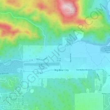
Nome: Mappa topografica Big Bear City, altitudine, rilievo.
Altitudine media: 2.155 m
Altitudine minima: 2.042 m
Altitudine massima: 2.504 m
Fai una donazione
Preparati per la tua prossima avventura:
In qualità di associato Amazon, questo sito riceve una commissione sugli acquisti idonei senza alcun costo aggiuntivo per te.
Altre mappe topografiche
Clicca su una mappa per visualizzarne la topografia, l'altitudine e il rilievo.
Sugarloaf
United States > California > San Bernardino County > Big Bear City
Altitudine media: 2.154 m