
Fai una donazione
Preparati per la tua prossima avventura:
In qualità di associato Amazon, questo sito riceve una commissione sugli acquisti idonei senza alcun costo aggiuntivo per te.
Mappa topografica Lenore
Clicca sulla mappa per visualizzare l'altitudine.
Fai una donazione
Preparati per la tua prossima avventura:
In qualità di associato Amazon, questo sito riceve una commissione sugli acquisti idonei senza alcun costo aggiuntivo per te.
A proposito di questa mappa
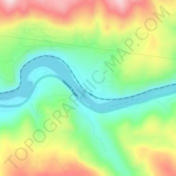
Nome: Mappa topografica Lenore, altitudine, rilievo.
Luogo: Lenore, Nez Perce County, Idaho, United States (46.49851 -116.56098 46.51851 -116.54098)
Altitudine media: 401 m
Altitudine minima: 261 m
Altitudine massima: 609 m
Fai una donazione
Preparati per la tua prossima avventura:
In qualità di associato Amazon, questo sito riceve una commissione sugli acquisti idonei senza alcun costo aggiuntivo per te.
Altre mappe topografiche
Clicca su una mappa per visualizzarne la topografia, l'altitudine e il rilievo.
Lewiston
United States > Idaho > Nez Perce County
According to the U.S. Census Bureau, the city has a total area of 18.04 square miles (46.72 km2), of which 17.23 square miles (44.63 km2) is land and 0.81 square miles (2.10 km2) is water. Downtown Lewiston, at elevations between 740 feet (230 m) and 780 feet (240 m), is only slightly higher in elevation than…
Altitudine media: 334 m
Culdesac
United States > Idaho > Nez Perce County
Culdesac is located at 46°22′30″N 116°40′13″W / 46.37500°N 116.67028°W / 46.37500; -116.67028 (46.374883, -116.670333), at an elevation of 1,644 feet (501 m) above sea level.
Altitudine media: 588 m