
Mappa topografica Strathcona Science Provincial Park
Mappa interattiva
Clicca sulla mappa per visualizzare l'altitudine.
A proposito di questa mappa
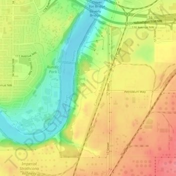
Nome: Mappa topografica Strathcona Science Provincial Park, altitudine, rilievo.
Altitudine media: 653 m
Altitudine minima: 608 m
Altitudine massima: 691 m
The park is situated in the North Saskatchewan River valley, on both banks of the river, at an elevation of 625 m (2,051 ft) and has a surface of 2.9 km2 (1.1 sq mi). It was established on December 12, 1979 and is maintained by Alberta Tourism, Parks and Recreation.
Altre mappe topografiche
Clicca su una mappa per visualizzarne la topografia, l'altitudine e il rilievo.
Sherwood Park
Canada > Alberta > Strathcona County > Sherwood Park
Sherwood Park, Strathcona County, Alberta, Canada
Altitudine media: 691 m