
Fai una donazione
Preparati per la tua prossima avventura:
In qualità di associato Amazon, questo sito riceve una commissione sugli acquisti idonei senza alcun costo aggiuntivo per te.
Mappa topografica Albany
Clicca sulla mappa per visualizzare l'altitudine.
Fai una donazione
Preparati per la tua prossima avventura:
In qualità di associato Amazon, questo sito riceve una commissione sugli acquisti idonei senza alcun costo aggiuntivo per te.
Albany
According to the United States Census Bureau, the city has a total area of 17.75 square miles (45.97 km2), of which 17.54 square miles (45.43 km2) is land and 0.21 square miles (0.54 km2) is water. Albany has 21.7 square miles (56 km2) within its urban growth boundary. Throughout the city limits and urban growth area, there are limited hills; the city is one of the lowest points along the Willamette Valley, with elevations ranging 180 to 430 feet (55 to 131 m) above sea level. The North Albany District has the most variable elevation, while the downtown and southern end of town have little elevation change throughout.
Fai una donazione
Preparati per la tua prossima avventura:
In qualità di associato Amazon, questo sito riceve una commissione sugli acquisti idonei senza alcun costo aggiuntivo per te.
A proposito di questa mappa
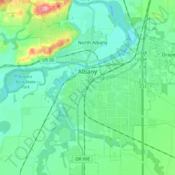
Nome: Mappa topografica Albany, altitudine, rilievo.
Luogo: Albany, Linn County, Oregon, United States (44.57758 -123.14740 44.67675 -123.03266)
Altitudine media: 71 m
Altitudine minima: 48 m
Altitudine massima: 158 m
Fai una donazione
Preparati per la tua prossima avventura:
In qualità di associato Amazon, questo sito riceve una commissione sugli acquisti idonei senza alcun costo aggiuntivo per te.
Altre mappe topografiche
Clicca su una mappa per visualizzarne la topografia, l'altitudine e il rilievo.