
Mappa topografica Grantham
Clicca sulla mappa per visualizzare l'altitudine.
A proposito di questa mappa
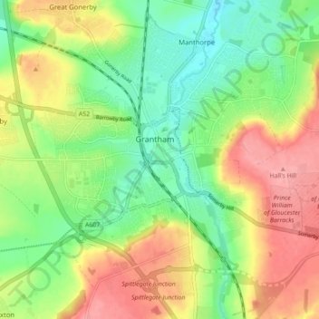
Nome: Mappa topografica Grantham, altitudine, rilievo.
Altitudine media: 84 m
Altitudine minima: 43 m
Altitudine massima: 135 m
Altre mappe topografiche
Clicca su una mappa per visualizzarne la topografia, l'altitudine e il rilievo.
Scottlethorpe
United Kingdom > England > Lincolnshire > South Kesteven > Edenham
Altitudine media: 49 m
Moor Barn
United Kingdom > England > Lincolnshire > South Kesteven > Hough-on-the-Hill
Altitudine media: 31 m
Old Somerby
United Kingdom > England > Lincolnshire > South Kesteven > Old Somerby
Altitudine media: 115 m
Woolsthorpe-by-Belvoir
United Kingdom > England > Lincolnshire > South Kesteven
Altitudine media: 82 m
Sempringham
United Kingdom > England > Lincolnshire > South Kesteven > Pointon
Sempringham consists of a church and a holy well, with other houses east from the church scattered along the B1177 between Pointon and Billingborough. The church stands at an altitude of about 52 feet (16 m), on land rising out of flat fenland. Pointon is the chief township of the civil parish, which includes…
Altitudine media: 16 m
Uffington Park
United Kingdom > England > Lincolnshire > South Kesteven > Uffington
Altitudine media: 30 m
Careby
United Kingdom > England > Lincolnshire > South Kesteven > Little Bytham
Altitudine media: 56 m
Little Humby
United Kingdom > England > Lincolnshire > South Kesteven > Ropsley
Altitudine media: 81 m
Little Haw Wood
United Kingdom > England > Lincolnshire > South Kesteven > Castle Bytham
Altitudine media: 92 m
Witham on the Hill
United Kingdom > England > Lincolnshire > South Kesteven > Witham on the Hill
Altitudine media: 43 m
Grimsthorpe
United Kingdom > England > Lincolnshire > South Kesteven > Grimsthorpe
Altitudine media: 55 m
Stainfield
United Kingdom > England > Lincolnshire > South Kesteven > Hanthorpe
Altitudine media: 40 m