
Mappa topografica Bally
Mappa interattiva
Clicca sulla mappa per visualizzare l'altitudine.
Bally
Bally is located at 22°39′N 88°20′E / 22.65°N 88.34°E / 22.65; 88.34 and also the northern-most part of Howrah city. It has an average elevation of 15 metres (49 feet). Bally is separated from Uttarpara, Hooghly by Bally Canal (Bally Khal) at its north. A Bridge was constructed over Bally Canal in 1846 to join the two localities.
A proposito di questa mappa
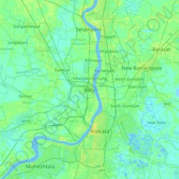
Nome: Mappa topografica Bally, altitudine, rilievo.
Altitudine media: 6 m
Altitudine minima: -3 m
Altitudine massima: 23 m