
Mappa topografica Dublin
Clicca sulla mappa per visualizzare l'altitudine.
Dublin
Located on the Glaciated Allegheny Plateau, Dublin has a relatively flat topography. Nevertheless, there are numerous ravines surrounding the tributaries of the Scioto River, which make for steep cliffs in some areas. Elevations range from 780 feet (240 m) above sea level where the Scioto River leaves the city at Hayden Run Road, while the high point is 1,000 feet (300 m) at Glacier Ridge Metro Park.
A proposito di questa mappa
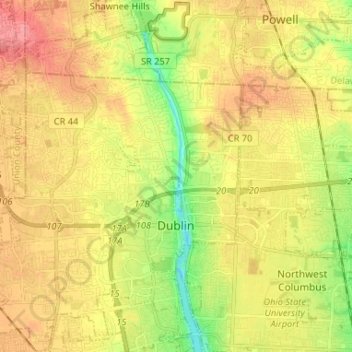
Nome: Mappa topografica Dublin, altitudine, rilievo.
Altitudine media: 275 m
Altitudine minima: 231 m
Altitudine massima: 311 m
Altre mappe topografiche
Clicca su una mappa per visualizzarne la topografia, l'altitudine e il rilievo.
Columbus
United States > Ohio > Franklin County > Columbus
The confluence of the Scioto and Olentangy rivers is just north-west of Downtown Columbus. Several smaller tributaries course through the Columbus metropolitan area, including Alum Creek, Big Walnut Creek, and Darby Creek. Columbus is considered to have relatively flat topography thanks to a large glacier that…
Altitudine media: 255 m