
Mappa topografica Birken
Clicca sulla mappa per visualizzare l'altitudine.
A proposito di questa mappa
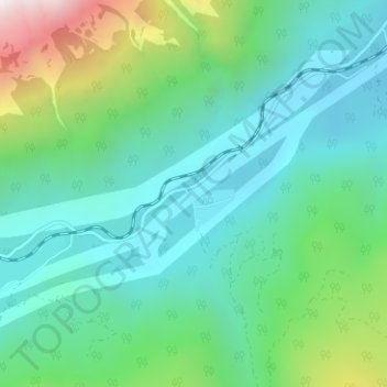
Nome: Mappa topografica Birken, altitudine, rilievo.
Altitudine media: 796 m
Altitudine minima: 386 m
Altitudine massima: 2.213 m
Altre mappe topografiche
Clicca su una mappa per visualizzarne la topografia, l'altitudine e il rilievo.
Lillooet Lake
Canada > British Columbia > Squamish-Lillooet Regional District > Area C (Pemberton Valley/Mount Currie/D'Arcy)
Altitudine media: 1.177 m
Joffre Lakes Provincial Park
Canada > British Columbia > Squamish-Lillooet Regional District > Area C (Pemberton Valley/Mount Currie/D'Arcy)
Staying on the trail is important for the preservation of the park environment, and for the safety of hikers. Lower Joffre Lake is a short distance away from the parking lot with no elevation gain. The trail to Middle and Upper Joffre lakes however is more challenging due to the greater elevation gain. Hiking…
Altitudine media: 1.911 m
Birkenhead Lake Provincial Park
Canada > British Columbia > Squamish-Lillooet Regional District > Area C (Pemberton Valley/Mount Currie/D'Arcy)
Altitudine media: 1.558 m
Lillooet Glacier
Canada > British Columbia > Squamish-Lillooet Regional District > Area C (Pemberton Valley/Mount Currie/D'Arcy)
Altitudine media: 2.171 m
Bishop Glacier
Canada > British Columbia > Squamish-Lillooet Regional District > Area C (Pemberton Valley/Mount Currie/D'Arcy)
Altitudine media: 1.932 m
Overlord Glacier
Canada > British Columbia > Squamish-Lillooet Regional District > Area C (Pemberton Valley/Mount Currie/D'Arcy)
Altitudine media: 2.133 m
Birkenhead Lake Provincial Park
Canada > British Columbia > Squamish-Lillooet Regional District > Area C (Pemberton Valley/Mount Currie/D'Arcy)
Altitudine media: 1.558 m
Joffre Lakes Provincial Park
Canada > British Columbia > Squamish-Lillooet Regional District > Area C (Pemberton Valley/Mount Currie/D'Arcy)
Staying on the trail is important for the preservation of the park environment, and for the safety of hikers. Lower Joffre Lake is a short distance away from the parking lot with no elevation gain. The trail to Middle and Upper Joffre lakes however is more challenging due to the greater elevation gain. Hiking…
Altitudine media: 1.911 m
Needles Glacier
Canada > British Columbia > Squamish-Lillooet Regional District > Area C (Pemberton Valley/Mount Currie/D'Arcy)
Altitudine media: 2.126 m