
Fai una donazione
Preparati per la tua prossima avventura:
In qualità di associato Amazon, questo sito riceve una commissione sugli acquisti idonei senza alcun costo aggiuntivo per te.
Mappa topografica New River
Clicca sulla mappa per visualizzare l'altitudine.
Fai una donazione
Preparati per la tua prossima avventura:
In qualità di associato Amazon, questo sito riceve una commissione sugli acquisti idonei senza alcun costo aggiuntivo per te.
New River
On its journey through the New River Gorge, the New River passes through an extensive geological formation. Emergent rocks and rock outcrops are found to provide diverse habitat producing rich and abundant flora and fauna species. In the gorge, there is typically a 1000 feet difference in elevation between the river bottom and the adjacent plateau. The New River dissects all physiographic provinces of the Appalachian Mountains, and therefore is believed to be a corridor facilitating the movement of southern plant and animal species into West Virginia. In addition to serving as a refuge for some species, New River Gorge provides a geographical barrier that limits the east-west distribution of other species.
Fai una donazione
Preparati per la tua prossima avventura:
In qualità di associato Amazon, questo sito riceve una commissione sugli acquisti idonei senza alcun costo aggiuntivo per te.
A proposito di questa mappa
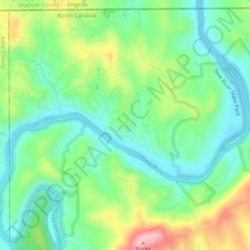
Nome: Mappa topografica New River, altitudine, rilievo.
Altitudine media: 803 m
Altitudine minima: 742 m
Altitudine massima: 928 m
Fai una donazione
Preparati per la tua prossima avventura:
In qualità di associato Amazon, questo sito riceve una commissione sugli acquisti idonei senza alcun costo aggiuntivo per te.
Altre mappe topografiche
Clicca su una mappa per visualizzarne la topografia, l'altitudine e il rilievo.
Fai una donazione
Preparati per la tua prossima avventura:
In qualità di associato Amazon, questo sito riceve una commissione sugli acquisti idonei senza alcun costo aggiuntivo per te.